The Connecticut Portal

Connecticut (/kəˈnɛtɪkət/ kə-NET-ih-kət) is a state in the New England region of the Northeastern United States. It borders Rhode Island to the east, Massachusetts to the north, New York to the west, and Long Island Sound to the south. Its capital is Hartford, and its most populous city is Bridgeport. Connecticut lies between the major hubs of New York City and Boston along the Northeast Corridor, where the New York metropolitan area, which includes four of Connecticut's seven largest cities, extends into the southwestern part of the state. Connecticut is the third-smallest state by area after Rhode Island and Delaware, and the 29th-most populous with more than 3.6 million residents as of 2024, ranking it fourth among the most densely populated U.S. states.
The state is named after the Connecticut River, the longest in New England, which roughly bisects the state and drains into the Long Island Sound between the towns of Old Saybrook and Old Lyme. The name of the river is in turn derived from anglicized spellings of Quinnetuket, a Mohegan-Pequot word for "long tidal river". Before the arrival of the first European settlers, the region was inhabited by various Algonquian tribes. In 1633, the Dutch West India Company established a small, short-lived settlement called House of Hope in Hartford. Half of Connecticut was initially claimed by the Dutch colony New Netherland, which included much of the land between the Connecticut and Delaware Rivers, although the first major settlements were established by the English around the same time. Thomas Hooker led a band of followers from the Massachusetts Bay Colony to form the Connecticut Colony, while other settlers from Massachusetts founded the Saybrook Colony and the New Haven Colony; both had merged into the first by 1664.
Connecticut's environmental history is shaped by Indigenous land stewardship, colonial displacement, industrial development, and modern environmental regulation. The Pequot and Mohegan peoples maintained sustainable relationships with the land prior to colonization, which were later disrupted by forced removal and legal restrictions on land and sovereignty. Industrial growth in the 19th and 20th centuries concentrated manufacturing along river systems, contributing to pollution and environmental inequality. In response, modern state and federal environmental policies have been developed to regulate pollution and protect natural resources. (Full article...)
 Recognized content -

The House at 130 Mohegan Avenue, also known as Rusty, the House of Steel or Steel House, is a prefabricated, modular, International Style house in New London, Connecticut, United States. The House was designed by Howard T. Fisher, who founded General Houses, Inc. in 1932. Winslow Ames, a professor of art history at Connecticut College and the art director of the Lyman Allyn Museum, had the home built after attending the Century of Progress Exposition in Chicago. The House is a single story 21 feet (6.4 m) by 37 feet (11 m) rectangular steel prefabricated home that rests upon a concrete slab. It originally had a flat roof and included an attached garage. Throughout the years, the house has undergone significant alteration, including the addition of a gable roof.
The house was used by Ames, and later by Connecticut College, as a rental property, until the structure was slated for demolition in 2004. The push to restore the house is credited to Doug Royalty, who worked with the college's Abigail Van Slyck. Completed in 2013, restoration cost $500,000 and involved several phases, including the dismantling, transportation, and reassembly of the house. The house was added to the Connecticut Historic Register in July 2007 and it was added to the National Register of Historic Places on October 28, 2009. (Full article...)
General images -

 Image 2The New Haven system (from History of Connecticut)
 Image 4Some bridges on the Merritt Parkway were constructed by workers paid by the US Works Progress Administration (from History of Connecticut)
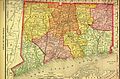 Image 51895 map from Rand McNally (from History of Connecticut)
 Image 7The Charter Oak in Hartford (from History of Connecticut)
 Image 8A map of Connecticut featuring highways and major routes alongside airports, buses, ferries, and railways. (from Transportation in Connecticut)
 Image 9The cover of the first timetable for Ridgefield to Branchville bus services (from Transportation in Connecticut)


 Image 13A Metro-North Railroad New Haven Line train at Stamford. (from Transportation in Connecticut)

 Image 16Police arrive at Sandy Hook Elementary, after the shooting (from History of Connecticut)


 Image 25A map showing Connecticut's towns in 1770. (from History of Connecticut)
 Image 27School zones generally have a speed limit of 25 mph. (from Transportation in Connecticut)
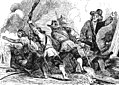 Image 28Pequot War of 1637 (from History of Connecticut)
 Image 30A map showing Connecticut's land claims. (from History of Connecticut)
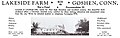 Image 32A 1942 advertisement for recreational lodging in Goshen stating that the facility is not a hotel and caters to Christian clientele specifically. (from History of Connecticut)
 Image 33Map showing the Connecticut, New Haven, and Saybrook colonies and the CT-NY dispute (from History of Connecticut)
 Image 35The March Route of Rochambeau's Army: Reservoir Road in Newtown. Few roads surpassed this quality in Connecticut until the mid-1800s. (from Transportation in Connecticut)


Selected picture -

State facts
- Nicknames: The Provisions State, The Land of Steady Habits, The Constitution State, The Nutmeg State
- Capital: Hartford
- Governor: Ned Lamont (D)
- Lieutenant Governor: Susan Bysiewicz (D)
- Secretary of State: Stephanie Thomas (D)
- Attorney General: William Tong (D)
- Senators: Chris Murphy (D), Richard Blumenthal (D)
- Representatives: Jahana Hayes (D), Jim Himes (D), Joe Courtney (D), John B. Larson (D), Rosa DeLauro (D)
- Total area: 5,543 mi2
- Land: 4,845 mi2
- Water: 698 mi2
- Highest elevation: 2,379 ft (Mount Frissell)
- Population 3,576,452 (2015 est)
- Admission to the Union: January 9, 1788 (5th)
State symbols:
- Animal: Sperm whale
- Bird: American Robin
- Fish: American Shad
- Flower: Mountain Laurel
- Fossil: Dinosaur Track
- Insect: European Praying Mantis
- Ship: USS Nautilus (SSN-571)
- Songs: Yankee Doodle
- Tree: Charter Oak
- Mineral: Almandine
Selected article -

Fairfield State Hospital (as it was known from 1929 to 1963) or Fairfield Hills Hospital (as it was known after 1963) was a psychiatric hospital in Newtown, Connecticut, which operated from 1931 until 1995. At its peak, the hospital housed over 4,000 patients. The entire facility was owned and operated by the State of Connecticut Department of Mental Health. The facility still stands, just southeast of the center of Newtown; the campus was listed on the National Register of Historic Places in 2024. (Full article...)
Did you know? -
- ... that a Connecticut TV station offered $100 to the first viewer who called in, twenty times—but nobody called?
- ... that the Saybrook Colony was sold to Connecticut for an annual payment of 180 pounds of equal quantities of wheat, peas, and either rye or barley?
- ... that televangelist Gene Scott went 65 hours without sleep when he barricaded himself in the studios of his Connecticut TV station to protest an order to pay taxes?
- ... that more than 90 percent of Connecticut voters in 1876 agreed to repeal the requirement of being white to vote?
Connecticut News
No recent news
Categories

Related WikiProjects

WikiProject Connecticut • WikiProject Connecticut routes • WikiProject UCONN
Selected panorama

Topics
Related portals
Associated Wikimedia
The following Wikimedia Foundation sister projects provide more on this subject:
-
 Commons
Free media repository -
 Wikidata
Free knowledge base -
 Wikiquote
Collection of quotations -
 Wikisource
Free-content library -
 Wikiversity
Free learning tools -
 Wikivoyage
Free travel guide -
 Wiktionary
Dictionary and thesaurus


