.png) LRO image | |
| Coordinates | 29°43′N 3°59′W / 29.72°N 3.99°W / 29.72; -3.99 |
|---|---|
| Diameter | 81.04 km (50.36 mi)[1] |
| Depth | 1.6 km (0.99 mi)[2] |
| Colongitude | 4° at sunrise |
| Formation | Late Imbrian[3] |
| Eponym | Archimedes |


Archimedes is a large lunar impact crater on the eastern edges of the Mare Imbrium.[4] It was named by the IAU in 1935.[1] T. W. Webb described it as "one of the most regular walled plains", "the outer slope of the wall is very complex; a magnificent object against the rising or setting Sun".[5]
Description
On the lunar geologic timescale, Archimedes dates to the Upper (Late) Imbrian age.[3]: Table 11.2. The diameter of Archimedes is the largest of any crater on the Mare Imbrium.[4] The rim has a significant outer rampart brightened with ejecta and the upper portion of a terraced inner wall, but lacks the ray system associated with younger craters. A triangular promontory extends 30 kilometers from the southeast of the rim.
The interior of the crater lacks a central peak, and is flooded with lava. It is devoid of significant raised features, although there are a few tiny meteor craters near the rim. Scattered wisps of bright ray material lie across the floor, most likely deposited by the impact that created Autolycus.[6]: 41
To the south of Archimedes extends the Montes Archimedes, a mountainous region. On the southeastern rim is the Palus Putredinis, a lava-flooded plain containing a system of rilles named the Rimae Archimedes, which extends over 150 kilometers. North-northwest of Archimedes stand the Montes Spitzbergen, a string of peaks in the Mare Imbrium. East of Archimedes is the crater Autolycus. Northeast of Archimedes is the prominent crater Aristillus. The lava plain between Archimedes, Aristillus, and Autolycus forms the Sinus Lunicus bay of Mare Imbrium. A wrinkle ridge leads away from Archimedes toward the north-northwest, crossing this mare.[6]: 41
The stretch of lunar surface between Archimedes and Autolycus was the site of the crash-landing of the Soviet probe Luna 2. This was the first craft to reach the surface of the Moon, landing September 13, 1959.[3]: Ch. 1
This crater is named after the Greek scientist Archimedes.[1] Like many of the craters on the Moon's near side, it was given its name by Giovanni Riccioli, whose 1651 nomenclature system has become standardized.[7]: 213 Earlier lunar cartographers had given the feature different names. Michael van Langren's 1645 map calls it "Roma" after the city of Rome.[7]: 198 Johannes Hevelius called it "Mons Argentarius" after Monte Argentario region in Italy.[7]: 202
Satellite craters
By convention these features are identified on lunar maps by placing the letter on the side of the crater midpoint that is closest to Archimedes.
| Archimedes[6]: 292 | Latitude | Longitude | Diameter |
|---|---|---|---|
| C | 31.6° N | 1.5° W | 8 km |
| D | 32.2° N | 2.6° W | 5 km |
| E | 25.0° N | 7.2° W | 3 km |
| G | 29.1° N | 8.2° W | 3 km |
| H | 23.9° N | 7.0° W | 4 km |
| L | 25.0° N | 2.6° W | 4 km |
| M | 26.1° N | 3.2° W | 3 km |
| N | 24.1° N | 3.9° W | 3 km |
| P | 25.9° N | 2.5° W | 3 km |
| Q | 28.5° N | 2.4° W | 3 km |
| R | 26.0° N | 6.6° W | 4 km |
| S | 29.5° N | 2.7° W | 3 km |
| T | 30.3° N | 5.0° W | 3 km |
| U | 32.8° N | 1.9° W | 3 km |
| V | 32.9° N | 4.0° W | 3 km |
| W | 23.8° N | 6.2° W | 4 km |
| X | 31.0° N | 8.0° W | 2 km |
| Y | 29.9° N | 9.5° W | 2 km |
| Z | 26.8° N | 1.4° W | 2 km |
The following craters have been renamed by the IAU.[8]
- Archimedes A - See Bancroft (crater).
- Archimedes F - See MacMillan (crater).
- Archimedes K - See Spurr (crater).
Gallery
 Lunar Orbiter 4 image
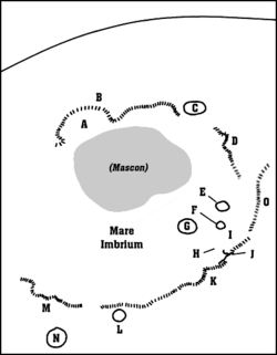 Detail map of Mare Imbrium's features. Archimedes is the feature marked "G".
 LRO image of the contact of the crater wall (lower left) and the floor (upper right)


References
- "Archimedes (crater)". Gazetteer of Planetary Nomenclature. USGS Astrogeology Research Program.
- Pike, R. J. (September 1976). "Crater Dimensions from Apollo Data and Supplemental Sources". The Moon. 15 (3–4): 463–477. Bibcode:1976Moon...15..463P. doi:10.1007/BF00562253.
- Wilhelms, Don E.; McCauley, John F.; Trask, Newell J. (1987). The geologic history of the Moon. USGS Professional Paper 1348. Washington: U.S. Government Printing Office.
- Moore, Patrick (2001). On the Moon. Sterling Publishing Co. ISBN 978-0-304-35469-6.
- Webb, Rev. T. W. (1962). Celestial Objects for Common Telescopes (6th revised ed.). Dover. pp. 124, 154–159. Reprint: ISBN 978-0-486-20917-3
- Bussey, B.; Spudis, P. (2004). The Clementine Atlas of the Moon. New York: Cambridge University Press. ISBN 978-0-521-81528-4.
- Whitaker, Ewen A. (1999). Mapping and Naming the Moon. Cambridge University Press. ISBN 978-0-521-62248-6.
- Moore, Patrick; Rees, Robin (2014). Patrick Moore's Data Book of Astronomy (2 ed.). Cambridge University Press. pp. 50–79. ISBN 978-1-139-49522-6.
Sources
- Price, Fred W. (1988). The Moon Observer's Handbook. Cambridge University Press. ISBN 978-0-521-33500-3.
- Rükl, Antonín (1990). Atlas of the Moon. Kalmbach Books. ISBN 978-0-913135-17-4.
- Wlasuk, Peter T. (2000). Observing the Moon. Springer. ISBN 978-1-85233-193-1.
External links
- "Featured Image: Archimedes - Mare Flooded Crater!". Lunar Reconnaissance Orbiter. NASA. March 2, 2011. Archived from the original on 16 March 2011. Retrieved 2011-03-18.
- High resolution lunar overflight video by Seán Doran, based on LRO data, that passes over Archimedes about one third of the way through (see album for more)