Aubry-le-Panthou | |
|---|---|
 The church in Aubry-le-Panthou | |
 Location of Aubry-le-Panthou | |
 Aubry-le-Panthou  Aubry-le-Panthou | |
| Coordinates: 48°51′05″N 0°14′01″E / 48.8514°N 0.2336°E / 48.8514; 0.2336 | |
| Country | France |
| Region | Normandy |
| Department | Orne |
| Arrondissement | Mortagne-au-Perche |
| Canton | Vimoutiers |
| Intercommunality | CC Vallées Auge Merlerault |
| Government | |
| • Mayor (2020–2026) | Jean-Claude Laigre[1] |
Area 1 | 6.85 km2 (2.64 sq mi) |
| Population (2023)[2] | 133 |
| • Density | 19.4/km2 (50.3/sq mi) |
| Time zone | UTC+01:00 (CET) |
| • Summer (DST) | UTC+02:00 (CEST) |
| INSEE/Postal code | 61010 /61120 |
| Elevation | 133–256 m (436–840 ft) (avg. 172 m or 564 ft) |
| 1 French Land Register data, which excludes lakes, ponds, glaciers > 1 km2 (0.386 sq mi or 247 acres) and river estuaries. | |
Aubry-le-Panthou (French pronunciation: [obʁi lə pɑ̃tu] ) is a commune in the Orne department in north-western France.
Geography
The commune along with another 11 communes is part of a 1,400 hectare, Natura 2000 conservation area, called the Haute Vallée de la Touques et affluents.[3]
The River Vie runs through the commune in addition to two streams, the Val Roger & the Mont-Ormel.[4]
Population
| Year | Pop. | ±% p.a. |
|---|---|---|
| 1968 | 207 | — |
| 1975 | 121 | −7.38% |
| 1982 | 89 | −4.29% |
| 1990 | 106 | +2.21% |
| 1999 | 93 | −1.44% |
| 2007 | 98 | +0.66% |
| 2012 | 107 | +1.77% |
| 2017 | 115 | +1.45% |
| 2023 | 133 | +2.45% |
| Source: INSEE[6] | ||
Points of Interest
- Coteau des Champs-Genêts is a 29 hectare Sensitive Natural Space of Orne.[7] The reserve features the following fauna and flora Camargue horses, Boloria dia, Adonis blue, Vincetoxicum hirundinaria, Dactylorhiza viridis and Gentiana cruciata.[8]
- Vajradhara-Ling is a Buddhist centre based in the commune since 1982.[9]
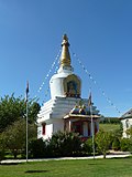 Vajradhara-Ling
 Aubry-le-Panthou Church
 Castle of Osmont


See also
References
- "Répertoire national des élus: les maires" (in French). data.gouv.fr, Plateforme ouverte des données publiques françaises. 13 September 2022.
- "Populations de référence 2023" (in French). National Institute of Statistics and Economic Studies. 18 December 2025.
- "INPN - FSD Natura 2000 - FR2500103 - Haute Vallée de la Touques et affluents - Description".
- Sandre. "Fiche cours d'eau - La Vie (I13-0400)".
- "Aubry-le-Panthou · 61120, France". Aubry-le-Panthou · 61120, France.
- Population municipale entre 1968 et 2023, INSEE
- "Espaces Naturels Sensibles de l'Orne | Conservatoires d'espaces naturels de Normandie". cen-normandie.fr.
- "COTEAU DES CHAMPS GENETS | Conservatoires d'espaces naturels de Normandie". cen-normandie.fr.
- "Aubry-le-Panthou. Trente-cinq ans de méditation bouddhiste [VIDEO]". Ouest-France.fr. 2 June 2017.