Bang Khonthi
บางคนที | |
|---|---|
 The Nativity of Our Lady Cathedral, Bang Nok Kwaek, Bang Khonthi District | |
 District location in Samut Songkhram province | |
| Coordinates: 13°28′8″N 99°56′26″E / 13.46889°N 99.94056°E / 13.46889; 99.94056 | |
| Country | Thailand |
| Province | Samut Songkhram |
| Seat | Kradangnga |
| Area | |
• Total | 77.5 km2 (29.9 sq mi) |
| Population (2023)[1] | |
• Total | 30,389 |
| • Density | 392/km2 (1,020/sq mi) |
| Time zone | UTC+7 (ICT) |
| Postal code | 75120 |
| Calling code | 034 |
| ISO 3166 code | TH-7502 |
Bang Konthi (Thai: บางคนที, pronounced [bāːŋ kʰōn.tʰīː]) is a district (amphoe) of Samut Songkhram province.
Geography
The district is slightly inland at the northwestern tip of the Bay of Bangkok. Neighboring districts are (from the east clockwise) Mueang Samut Songkhram, Amphawa, Wat Phleng, Mueang Ratchaburi and Damnoen Saduak, the latter three in Ratchaburi province. The Mae Klong river flows through the district.
History
In 1913, the district was enlarged by incorporating the district Mae Nam Om. Additionally, it was reassigned from Ratchaburi to Samut Songkhram.[2] In 1914 the name was changed from Si Muen (สี่หมื่น) to Bang Konthi.[3]
Administration
Central government
The district is divided into thirteen subdistricts (tambons), which are further subdivided into 101 villages (mubans).[1]
| No. | Subdistrict | Thai | Villages | Pop. |
|---|---|---|---|---|
| 1. | Kradangnga | กระดังงา | 13 | 5,084 |
| 2. | Bang Sakae | บางสะแก | 7 | 1,912 |
| 3. | Bang Yi Rong | บางยี่รงค์ | 10 | 1,663 |
| 4. | Rong Hip | โรงหีบ | 9 | 2,013 |
| 5. | Bang Khonthi | บางคนที | 9 | 2,208 |
| 6. | Don Manora | ดอนมะโนรา | 8 | 3,942 |
| 7. | Bang Phrom | บางพรม | 8 | 2,626 |
| 8. | Bang Kung | บางกุ้ง | 7 | 1,530 |
| 9. | Chom Pluak | จอมปลวก | 7 | 3,059 |
| 10. | Bang Nok Khwaek | บางนกแขวก | 7 | 1,280 |
| 11. | Yai Phaeng | ยายแพง | 5 | 1,427 |
| 12. | Bang Krabue | บางกระบือ | 5 | 1,960 |
| 13. | Ban Pramote | บ้านปราโมทย์ | 6 | 1,685 |
| Total | 101 | 30,389 |

Local government
As of December 2023 there are four subdistrict municipalities (thesaban tambon), Bang Krabue, Bang Yi Rong cover the whole subdistrict and Kradangnga covers a part of the subdistrict and Bang Nok Khwaek covers also a part of Bang Khonthi subdistrict. There are also seven subdistrict administrative organizations - SAO (ongkan borihan suan tambon - o bo to). Don Manora, Chom Pluak and Bang Phrom cover the whole subdistrict, while Kradangnga covers a part of the subdistrict. Six former SAO's were combined into three SAO's: Bang Sakae with Ban Promote, Rong Hip with Bang Kung and Bang Khonthi with Yai Phaeng.[1]
| Subdistrict municipality | Pop. | website |
|---|---|---|
| Kradangnga | 2,103 | kdg |
| Bang Krabue | 1,960 | bangkrabuecity |
| Bang Yi Rong | 1,663 | bangyirong |
| Bang Nok Kwaek subd. mun. | Pop. | bnk |
| Bang Nok Kwaek | 1,280 | |
| Bang Khonthi | 426 | |
| Total | 1,706 |
| Subdistrict adm.org-SAO | Pop. | website |
|---|---|---|
| Don Manora | 3,942 | donmanora |
| Chom Pluak | 3,059 | jompluak |
| Kradangnga | 2,981 | |
| Bang Phrom | 2,626 | bangprom |
| Bang Sakae-SAO | Pop. | bangsakae |
| Bang Sakae | 1,912 | |
| Ban Promote | 1,685 | |
| Total | 3,597 |
| Rong Hip-SAO | Pop. | rongheep |
| Rong Hip | 2,013 | |
| Bang Kung | 1,530 | |
| Total | 3,543 |
| Bang Khonthi-SAO | Pop. | bangkhontee |
| Bang Khonthi | 1,782 | |
| Yai Phaeng | 1,427 | |
| Total | 3,209 |
Healthcare
Hospital
There is Napalai hospital in Kradangnga subdistrict with 90 beds.
Health promoting hospitals
There are total thirteen health-promoting hospitals in the district, of which; one in every subdistrict but Don Manora subdistrict has two.[4]
Religion
There are twenty-five Theravada Buddhist temples in the district.
One in Bang Sakae, Don Manora, Chom Pluak, Bang Krabue and Bang Pramote, two in Bang Khonthi, Bang Phrom and Bang Nok Khwaek, three in Rong Hip, five in Bang Kung, six in Kradangnga.[5][6]
Sights
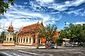
Bang Nok Khwaek is the centre of the Roman Catholic Diocese of Ratchaburi. The Nativity of Our Lady Cathedral was built in 1890 in French Gothic style.
Khai Bang Kung is a former river fort, which was of great importance during the late Ayutthaya and Thonburi periods. After being deserted for almost 200 years, a Boy Scout camp was established at the site in 1967, and a shrine was built commemorating King Taksin.
Wat Charoen Sukharam Worawihan is the most important Buddhist temple in the district. The main Buddha figure in the Ubosot (ordination hall) is called Luang Pho Toa. It consists of a laterite core covered with plaster and gilded, and is in the style of the Sukhothai period.
Gallery
 Wat Pramot, tambon Ban Pramot
 Wat Bang Kung, tambon Bang Kung
 Bang Kung camp, tambon Bang Kung
 Mae Klong river
 Catholic church at tambon Bang Yi Rong
 Coconut plantation at tambon Bang Yi Rong
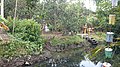 Orchard at tambon Kradangnga


.jpg)
.jpg)

References
- "Official statistics registration systems". Department of Provincial Administration. Retrieved 10 January 2025, year 2023 >village level >ExcelFile >no.7501-7599 >Excel line 79672-80009
{{cite web}}: CS1 maint: postscript (link) - แจ้งความกระทรวงมหาดไทย เรื่อง ยกเลิกอำเภอแม่น้ำอ้อม กับ อำเภอสี่หมื่น เมืองราชบุรีมาเป็นเขตเมือง สมุทรสงคราม (PDF). Royal Gazette (in Thai). 30 (ง): 1073. 1913-08-24. Archived from the original (PDF) on June 7, 2012.
- ประกาศกระทรวงมหาดไทย เรื่อง เปลี่ยนชื่ออำเภอ (PDF). Royal Gazette (in Thai). 31 (ง): 1514. 1914-10-11. Archived from the original (PDF) on June 7, 2012.
- "Name-of-the-hospital-service-unit". Ministry of Public Health. Retrieved 14 March 2025, >health zone 5 no.08528-08540
{{cite web}}: CS1 maint: postscript (link) - "list of temples". Retrieved 14 March 2025, Sect Maha Nikai no.275020101-275021301
{{cite web}}: CS1 maint: postscript (link) - "list of temples". Retrieved 14 March 2025, Sect Dhammayut no.675020101-675020801
{{cite web}}: CS1 maint: postscript (link)
External links
- amphoe.com (Thai)