General Tinio | |
|---|---|
 Welcome Arch | |
 Seal | |
 Map of Nueva Ecija with General Tinio highlighted | |
 Interactive map of General Tinio | |
.svg) General Tinio Location within the Philippines | |
| Coordinates: 15°21′N 121°03′E / 15.35°N 121.05°E / 15.35; 121.05 | |
| Country | Philippines |
| Region | Central Luzon |
| Province | Nueva Ecija |
| District | 4th district |
| Founded | 1921 |
| Named after | Manuel Tinio |
| Barangays | 13 (see Barangays) |
| Government | |
| • Type | Sangguniang Bayan |
| • Mayor | Sherry Ann D. Bolisay |
| • Vice Mayor | Melvin S. Pascual |
| • Representative | Emerson D. Pascual |
| • Municipal Council | Members
|
| • Electorate | 43,627 voters (2025) |
| Area | |
• Total | 245.29 km2 (94.71 sq mi) |
| Elevation | 56 m (184 ft) |
| Highest elevation | 113 m (371 ft) |
| Lowest elevation | 32 m (105 ft) |
| Population (2024 census)[3] | |
• Total | 58,093 |
| • Density | 236.83/km2 (613.40/sq mi) |
| • Households | 13,137 |
| Economy | |
| • Income class | 1st municipal income class |
| • Poverty incidence | 12.61 |
| • Revenue | ₱ 343.7 million (2024) |
| • Assets | ₱ 620.5 million (2024) |
| • Expenditure | ₱ 303.4 million (2024) |
| • Liabilities | ₱ 245.5 million (2024) |
| Service provider | |
| • Electricity | Nueva Ecija 2 Area 2 Electric Cooperative (NEECO 2 A2) |
| Time zone | UTC+8 (PST) |
| ZIP code | 3104 |
| PSGC | |
| IDD : area code | +63 (0)44 |
| Native languages | Southern Alta Tagalog Ilocano |
| Website | www |
General Tinio, formerly known as Papaya, is a first-class municipality in the 4th district of Nueva Ecija, Philippines.[5] According to the 2024 census, it has a population of 58,093 people.[6] It was known as Papaya until 1957, when it was renamed in honor of General Manuel Tinio through Republic Act No. 1665.[7]The municipality is located at the western foothills of the Sierra Madre, adjoining the Fort Magsaysay Army Reservation on the northeastern side.[8]
Early references and Spanish period

The earliest known documentary references to Papaya appear in the Erección de los Pueblos project of the National Archives of the Philippines. It was found that Spanish colonial records concerning the revised proposal of separation of the barrio of San Isidro and San Antonio Abad from its mother town, Gapan in the Province of Pampanga. The settlement document surrounding the proposed separation mentions that barrios Papaya and Rio Chico - which will eventually be part of the town of Papaya - will remain to be part of Gapan.[10]
The document records that, following the proposed civil separation of San Isidro and San Antonio Abad from Gapan, the latter would retain several barrios, including Papaya and Rio Chico, together with the barrios Mapison (Mapisong), Calius (Callos), San Roque, San Roque-Cabaong, Sta. Cruz, San Nicolas, Pambuan, Castellano, and others.[10] These records establish that Papaya and Rio Chico were already recognized settlements decades before Papaya became an independent municipality.
At the time these documents were prepared, Gapan formed part of the Province of Pampanga. In 1848, however, the colonial government under Governor-General Narciso Clavería y Zaldúa transferred Gapan and its dependent settlements to the Province of Nueva Ecija, placing Papaya within the territorial jurisdiction of Nueva Ecija for the remainder of the Spanish period.[11][12]
By the mid-nineteenth century, barrio Papaya was sufficiently established to be recorded in the Diccionario Geográfico-Estadístico-Histórico de las Islas Filipinas (1851) by Manuel Buzeta and Felipe Bravo, which described it as a visita of Gapan. The designation indicated a settled chapel-community that remained administratively and ecclesiastically dependent upon the parish and civil authorities of Gapan.[13]
During the late Spanish and early American periods, Pias, originally a sitio of barrio Rio Chico, developed into a separate barrio under Peñaranda.[14]
Additional evidence of the antiquity of the settlement appears in biographical accounts associated with notable Filipinos. The National Commission for Culture and the Arts identifies National Artist for Music Felipe Padilla de León as having been born in the sitio of Papaya, then part of Peñaranda, Nueva Ecija, in 1912, reflecting the continued use of the place-name prior to the creation of the municipality of Papaya.[15]
Local historical accounts likewise identify Mamerto Padolina, popularly known as Tinting Muerto, as one of the revolutionaries under General Urbano Lacuna of the Unang Sigaw ng Nueva Écija in San Isidro, principal figures in the movement that led to the establishment of Papaya as an independent municipality. Historical records describe him as having settled in Barrio Papaya after leaving Bulacan and later becoming a leading advocate for the barrio's separation from Peñaranda, culminating in the creation of the municipality on 7 January 1921.[16]
Precolonial and early inhabitants
Prior to Spanish documentation, the area that would become Papaya was already inhabited by indigenous groups. Mid-20th century historical accounts describe the presence of Dumagat (Aeta-related) populations in the forested and upland areas surrounding the settlement, coexisting with lowland communities along river systems such as the Rio Chico.[17] These groups formed part of the earliest known inhabitants of the region and contributed to its early socio-cultural landscape.
Archaeological evidence further supports early human activity in the area. The Arubo 1 site in present-day General Tinio has yielded stone tools, including proto-handaxes and Levallois-like flakes, suggesting habitation dating back to the Lower or Middle Paleolithic period.[18] This evidence situates the area within a broader pattern of early human occupation in Central Luzon.
Geography
Location and boundaries
General Tinio is a landlocked municipality in the province of Nueva Ecija, located in the eastern portion of Central Luzon. It lies along the transitional zone between the Central Luzon Basin and the western foothills of the Sierra Madre mountain range.[19]
It is bounded by Peñaranda, Nueva Ecija to the west, San Leonardo, Nueva Ecija to the northwest, Fort Magsaysay in Palayan, Nueva Ecija to the north, Gapan to the south, and Dingalan of Aurora province to the east across the Sierra Madre range.[20]
The municipality’s location reflects settlement patterns consistent with Spanish colonial planning principles under the Leyes de Indias, where towns were established near river systems to support agriculture, transport, and administration.
Topography and landforms
General Tinio occupies a geomorphological transition zone between lowland alluvial plains and upland mountainous terrain associated with the Sierra Madre.[19]
The western portion consists of generally level to rolling plains formed by fluvial deposition, while the eastern portion rises into hilly and mountainous terrain. Elevation ranges from approximately 30 meters above sea level in lowland areas to over 1,200 meters in upland barangays such as Pias.[21]
The variation in terrain influences land use patterns across the municipality. The lowland plains, formed by fertile alluvial deposits, are predominantly used for irrigated agriculture, particularly rice cultivation and other crops typical of Central Luzon. In contrast, the upland and sloping areas toward the Sierra Madre are used for eco-tourism[22] and to more suited diversified land use, including agroforestry systems that combine trees with crops to improve soil stability and reduce erosion.[23][24]
Such upland environments are commonly associated with mixed vegetation cover and tree-based farming systems in the Philippines, reflecting both ecological constraints and adaptation to terrain.[25]
A defining landform is the karst landscape of Minalungao National Park, established as a protected area under Republic Act No. 5100 (1967).[26]
The park is characterized by:
- Limestone cliffs rising up to 16 meters along the Peñaranda River
- Karst features such as caves, fissures, sinkholes, and aquifers
- Secondary-growth forest ecosystems
Recent ecological studies describe Minalungao as a karst forest system covering approximately 2,000 hectares of limestone terrain.[27]
Hydrography
General Tinio is traversed by four principal river systems identified in archaeological and environmental studies:
- Peñaranda River – a major river system in Nueva Ecija
- Rio Chico River – a tributary within the Pampanga River basin
- Sumacbao River – the largest tributary of the Peñaranda River
- Tabuating River – a northern tributary linked to irrigation systems
These rivers are documented in archaeological surveys of the Arubo site and form part of the broader Pampanga River watershed.[28]
River systems in the municipality originate partly from upland forest areas and sustain irrigation networks such as the Upper Tabuating Irrigation Project.[29]
Geology
Regional geological setting
General Tinio lies at the interface of the Central Luzon Basin and the Sierra Madre mountain system. Its geology consists primarily of:
- Neogene sedimentary formations (sandstone, siltstone, claystone)
- Alluvial deposits from river systems
- Limestone and karst formations
Tectonic uplift associated with the Philippine Fault system and Sierra Madre orogeny, combined with fluvial processes, has shaped the municipality’s present landscape.[30]

Karst and limestone formations
The limestone formations of Minalungao represent a classic tropical karst environment formed through prolonged dissolution of carbonate rocks. These formations include:
- Steep limestone cliffs
- Subsurface drainage systems (aquifers)
- Sinkholes and caves
Soils associated with these formations include Annam loam (gravelly phase) and Sibul clay, both of which are documented in DENR protected area profiles.[21]
Karst soils are typically rich in calcium and magnesium, influencing vegetation and agricultural potential.[31]
Lithic resources and archaeology
The Arubo archaeological site in Barangay Rio Chico is a significant geological and cultural locality. Excavations revealed:
- Chert outcrops and boulders
- Stone tool assemblages (cores, flakes, proto-handaxes)
- Levallois-like flaking techniques
These chert deposits are interpreted as silicified residues from limestone and represent the only documented primary chert source used for stone tool production in the Philippines.[19]
The site has been linked to the Lower Palaeolithic record of the Philippines and demonstrates early human exploitation of geological resources.[19]
Stratigraphy and soils
Stratigraphic observations at Arubo indicate:
- Sandstone bedrock layers
- Overlying clay-rich sediments with iron oxide and calcite concentrations
Lowland areas contain fertile alluvial soils suitable for rice cultivation, while upland karst zones produce mineral-rich soils that support distinct vegetation communities.[32]
Soil pH studies in Nueva Ecija indicate generally acidic to neutral soils across the province.[33]
Geomorphic processes
The landscape of General Tinio continues to be shaped by:
- River incision from the Peñaranda, Rio Chico, Sumacbao, and Tabuating rivers
- Tectonic uplift associated with the Sierra Madre
These processes expose bedrock, transport sediments, and create fertile alluvial plains alongside karst gorges.[19]
Geological significance
General Tinio’s geology integrates three major systems:
- Alluvial and fluvial deposits supporting agriculture
- Karst limestone systems supporting biodiversity
- Lithic resources linked to prehistoric tool-making
This combination has sustained human-environment interaction from the Palaeolithic period to the present.[19]
Archaeology
The municipality of General Tinio, Nueva Ecija contains one of the most significant Paleolithic open-air lithic sites in Central Luzon, known as Arubo 1 Archaeological Site, located in Barangay Rio Chico near the Peñaranda River. Archaeological investigations conducted in 2001 by the University of the Philippines Archaeological Studies Program in collaboration with the National Museum of the Philippines identified the area as a lithic scatter associated with early human activity.[34][35]
The site lies within a fluvial landscape characterized by river terraces and access to local lithic raw materials, particularly chert. The presence of large chert nodules suggests that the area functioned as both a procurement zone and a stone tool production locality.[36]
Excavations and surface collections yielded lithic assemblages including flakes, cores, and pebble tools. Some artefacts show characteristics consistent with prepared-core reduction strategies, including Levallois-like flaking patterns, suggesting a relatively advanced understanding of lithic production techniques for the region.[37]
A notable discovery is a proto-handaxe, a bifacial tool type associated with Acheulean-like technologies of the Lower Paleolithic.[38]
Such finds are rare in Island Southeast Asia and are often discussed in relation to the Movius Line hypothesis, which proposed a technological divide in early stone tool traditions between western and eastern Eurasia.[39][40]
The Arubo assemblage contributes to broader debates on early human dispersal and technological variability in Island Southeast Asia, suggesting that prehistoric populations in the Philippines may have developed more complex lithic traditions than previously assumed.[41]
The Arubo 1 Archaeological Site is notable as one of the earliest and most significant Paleolithic lithic assemblages documented in the Philippines, with artefacts exhibiting relatively complex and organized stone tool reduction strategies for the region.[37][41]
These findings have been discussed within broader syntheses of Island Southeast Asian prehistory as part of reassessments of early lithic variability and technological development in the archipelago.[42]
Climate
General Tinio has a tropical monsoon climate (Type I under the Corona classification), characterized by:
- A wet season from May to November
- A dry season from December to April
Climate data from nearby stations indicate average temperatures ranging from 20 °C to 34 °C and annual rainfall of approximately 661 mm.[43]
| Climate data for General Tinio, Nueva Ecija | |||||||||||||
|---|---|---|---|---|---|---|---|---|---|---|---|---|---|
| Month | Jan | Feb | Mar | Apr | May | Jun | Jul | Aug | Sep | Oct | Nov | Dec | Year |
| Mean daily maximum °C (°F) | 29 (84) |
30 (86) |
31 (88) |
34 (93) |
33 (91) |
31 (88) |
30 (86) |
29 (84) |
29 (84) |
30 (86) |
30 (86) |
29 (84) |
30 (87) |
| Mean daily minimum °C (°F) | 20 (68) |
20 (68) |
20 (68) |
22 (72) |
24 (75) |
24 (75) |
24 (75) |
24 (75) |
24 (75) |
23 (73) |
22 (72) |
21 (70) |
22 (72) |
| Average precipitation mm (inches) | 4 (0.2) |
4 (0.2) |
5 (0.2) |
11 (0.4) |
66 (2.6) |
99 (3.9) |
127 (5.0) |
113 (4.4) |
99 (3.9) |
84 (3.3) |
35 (1.4) |
14 (0.6) |
661 (26.1) |
| Average rainy days | 2.2 | 1.9 | 3.2 | 5.3 | 16.1 | 20.8 | 23.5 | 22.8 | 22.2 | 16.5 | 8.9 | 3.5 | 146.9 |
| Source: Meteoblue[44] | |||||||||||||
Demographics
Population census of General Tinio | |||||||||||||||||||||||||||||||||||||||||||||||||
|
| ||||||||||||||||||||||||||||||||||||||||||||||||
| Source: Philippine Statistics Authority[45][46][47][48] | |||||||||||||||||||||||||||||||||||||||||||||||||
Economy
Poverty incidence of General Tinio
35.19
12.48
19.70
15.69
15.38
14.92
5.10
12.61
Source: Philippine Statistics Authority[49][50][51][52][53][54][55][56]
Farming is the livelihood of the majority of the residents. Even though the municipality is located at the foot of the Sierra Madre Mountain Range, the topography is generally ideal for agricultural products such as palay and vegetables. A number of poultry broiler contract growers are also located in the municipality. Other industries include furniture and fixtures, backyard poultry, cattle and livestock, vegetable production, and minor agricultural livelihoods such as duck raising.
The remittances of numerous sons and daughters of Papaya abroad also help keep the economy of the town afloat. Papayanos can be relied to answer calls of assistance for the town's development.
Minalungao National Park is also one of the biggest attractions in the town, catering to numerous visitors each day.
Government
Administrative development
The administrative institutions governing the area now comprising General Tinio evolved through successive indigenous, Spanish, American, Japanese, post-war and contemporary Philippine systems of government. Although settlement in Papaya predates the establishment of the municipality, political authority, territorial jurisdiction, and local administrative structures changed significantly over time as broader governmental reforms were introduced in the Philippines.[57][58]
Indigenous governance
While no written records survive describing the political organization of present-day General Tinio before Spanish colonization, the area's indigenous communities are generally understood to have been governed through customary leadership exercised by tribal elders or chieftains. Elements of this traditional leadership continue among the Aeta communities of Barangay Palale, where customary authority exists alongside the statutory barangay government established under Philippine law.[59]
Spanish colonial administration (16th century–1898)
Spanish rule gradually incorporated Papaya into the colonial administrative hierarchy. During the nineteenth century, Papaya and Rio Chico formed part of the jurisdiction of Gapan before being transferred to the newly established pueblo of Peñaranda in 1851.[60][61]
At the local level, Papaya was administered by successive cabezas de barangay, who supervised tax collection, labor obligations, peace and order, census-taking and implementation of colonial regulations. The National Historical Commission of the Philippines preserves lists of the known cabezas who served Papaya during the Spanish period.[62]
These officials formed part of the municipal government headed by the gobernadorcillo, assisted by officers responsible for justice, policing, public works and finance under the colonial administrative system.[63]
American colonial administration (1898–1946)
Following the establishment of American civil government, the Spanish municipal system was gradually replaced by elective local governments under the Philippine Commission and subsequent legislation. Papaya remained a barrio of Peñaranda while barrio governance became increasingly institutionalized through elected or appointed barrio officials, public schools, civic organizations and local committees.[64][65]
The expansion of public education, public health and local infrastructure strengthened barrio administration during this period. Contemporary records document the participation of local officials and civic leaders, including Mamerto Padolina and other residents who contributed to barrio governance and community affairs.[66]
Creation of the Municipality of Papaya
The movement to establish an independent municipality was led by local residents headed by Mamerto Padolina, together with Judge Segundo Bernardo and Francisco Padolina. Their efforts culminated in the issuance of Executive Order No. 30 by Governor-General Francis Burton Harrison on 14 October 1920, which separated the barrios of Papaya, Rio Chico and Pias from the Municipality of Peñaranda to constitute the Municipality of Papaya, effective 1 January 1921.[67] The new municipality established an independent local government headed by an elected municipal mayor, vice mayor and Municipal Council in accordance with the municipal government system then in force under the American colonial administration. The former Barrio Papaya became the municipal barrio Población, while Rio Chico and Pias remained constituent barrios of the new municipality.[68]
Japanese occupation (1942–1945)
During the Japanese occupation of the Philippines, the municipal government of Papaya continued to function under the authority of the Japanese-sponsored Philippine Executive Commission (1942–1943) and later the Second Philippine Republic (1943–1945), while remaining subject to military supervision by the Imperial Japanese Army. Existing municipal officials generally continued to administer civil affairs, including the maintenance of local order and the implementation of directives issued by the occupation government, although their authority was constrained by wartime military administration.[69][70]
Post-war administration (1945–1972)
Following the restoration of the Philippine Commonwealth in 1945 and the recognition of Philippine independence in 1946, the municipal government resumed operations under the local government system inherited from the American period. Executive authority continued to be exercised by the municipal mayor, while legislative functions were performed by the elected Municipal Council in accordance with the Revised Administrative Code and subsequent election laws.[71]
During this period, the municipality continued to expand its administrative organization through the establishment of permanent municipal offices and the strengthening of barrio governments.
Renaming of Papaya to General Tinio
The municipality was officially renamed General Tinio on 20 June 1957 through Republic Act No. 1665, sponsored by Representative Celestino Juan, in honor of General Manuel Tinio y Bundoc (1877–1924), one of the youngest generals of the Philippine Revolution, former Governor of Nueva Ecija, and later the first Filipino Director of the Bureau of Lands.[72][73]
Martial law and barangay reorganization (1972–1986)
The declaration of martial law in 1972 introduced significant reforms to local government throughout the Philippines. Presidential Decree No. 86 formally recognized the barangay as the basic political unit of government and encouraged citizen participation through barangay assemblies.[74]
Subsequent decrees reorganized barrio governments into barangays nationwide, including those comprising General Tinio. During this period the municipality's present barangay structure was formalized, replacing the former barrio system inherited from the American period.[75]
Youth participation in local governance was likewise institutionalized through the establishment of the Kabataang Barangay under Presidential Decree No. 684 in 1975. Each barangay elected youth officials who represented young residents in community affairs and local development programs.[76] [77]
Contemporary local government
Following the People Power Revolution in 1986 and the adoption of the 1987 Constitution of the Philippines, local government underwent a process of decentralization intended to strengthen local autonomy and democratic participation. These constitutional principles were implemented through the enactment of the Local Government Code of 1991 (Republic Act No. 7160), which expanded the political, administrative and fiscal powers of local government units while institutionalizing participatory governance through local special bodies and sectoral representation.[78][79]
Today, General Tinio is governed by an elected municipal mayor as the local chief executive and the Sangguniang Bayan as the municipality's legislative body, in accordance with the Local Government Code of 1991. Municipal departments and offices administer public services, while the municipality's thirteen barangays serve as its primary political and administrative subdivisions, each headed by an elected barangay captain and Sangguniang Barangay.[80]
Youth participation in local governance is exercised through the Sangguniang Kabataan, which was reconstituted and strengthened under the Sangguniang Kabataan Reform Act of 2015 (Republic Act No. 10742). Each barangay elects a Sangguniang Kabataan chairperson and council, who represent the youth sector and implement programs for youth development within their respective communities.[81]
Indigenous governance also continues within the municipality through the recognition of the rights of Indigenous Cultural Communities under the Indigenous Peoples' Rights Act of 1997 (Republic Act No. 8371), which recognizes indigenous political structures and customary leadership in accordance with traditional practices.[82]
Administrative and territorial evolution of the Palale area
The upland area comprising present-day Barangay Palale occupies the western foothills of the Sierra Madre and has long been inhabited by indigenous communities, particularly the Aeta and Dumagat peoples. Although little documentary evidence survives regarding the area's political organization before Spanish colonization, these communities are generally understood to have been governed through customary leadership exercised by tribal elders or chieftains, consistent with indigenous governance elsewhere in the Sierra Madre. While the lowland settlements of Papaya, Rio Chico and Pias were incorporated into the Spanish colonial administrative system as barrios under Gapan and later Peñaranda, much of the mountainous interior remained beyond the effective reach of colonial civil administration, allowing indigenous communities to maintain their traditional patterns of settlement and customary leadership.[83][84]
During the American colonial period and the decades following Philippine independence, the government's administrative presence in the Sierra Madre expanded through forestry administration, military reservations and the establishment of permanent local government institutions. The creation of Fort Magsaysay in 1955 and the establishment of the City of Palayan as the provincial capital under Republic Act No. 4475 in 1965 resulted in territorial adjustments affecting neighboring local government units, including General Tinio, Laur and Santa Rosa.[85][86]
According to the official history of the Municipality of General Tinio, portions of the Palale area were subsequently detached from the municipality and placed under the jurisdiction of Palayan City following these territorial realignments. The change gave rise to a long-standing boundary controversy involving the affected upland communities. The dispute was ultimately resolved by the Supreme Court of the Philippines in Municipality of General Tinio v. City of Palayan (G.R. No. 169089), which upheld General Tinio's jurisdiction over the disputed territory, including the Palale area, thereby restoring its administration to the municipality.[87]
The legal framework governing indigenous communities was further strengthened through the enactment of the Indigenous Peoples' Rights Act of 1997 (Republic Act No. 8371), which recognizes Indigenous Political Structures, customary laws and leadership, ancestral domains and the participation of Indigenous Cultural Communities in local governance. Today, Barangay Palale forms one of the thirteen barangays of General Tinio under the Local Government Code of 1991, while the customary institutions of its indigenous communities continue to be recognized under Philippine law.[88][89]
Local municipal government
Early barrio officials before the establishment of the Municipality of Papaya (1921)
Early local leaders and barrio officials before the establishment of the Municipality of Papaya (1921) | ||||||||
|---|---|---|---|---|---|---|---|---|
|
Before the establishment of the Municipality of Papaya on 1 January 1921, the settlements of Papaya, Rio Chico and Pias formed part of the municipalities of Gapan and later Peñaranda. The following individuals are identified in the History and Cultural Life of Papaya, preserved by the National Historical Commission of the Philippines, as early cabezas de barangay, tenientes, and other prominent local leaders associated with the three barrios. The manuscript generally does not specify their dates of service.[90]
|
The municipal government of General Tinio is headed by the mayor, vice mayor, and the members of the Sangguniang Bayan.[91]
The following have led the town from its establishment in 1921 to the present:
| Cristobal Mangulabnan | Vice Martin Ramos | 1921–1922 |
| Getulio Bote, Sr. | Vice Martin Pajarillaga | 1922–1925 |
| Martin Pajarillaga | Vice Marcos Bote Sr. | 1925–1931 |
| Marcos Bote Sr. | Vice Daniel Padolina | 1931–1934 |
| Melquiades Ronquillo, Sr. | Vice Santiago Bolisay | 1934–1937 |
| Mayor | Vice Mayor | Term |
|---|---|---|
| Damaso Bolisay | 1937–1940 | |
| Getulio Bote | Vice Pedro Bulacan | 1940–1944 |
| Getulio Bote | Vice Angeles Bote | 1945 |
| Republic Era | ||
| Gerardo Rivera | Vice Angeles Bote | 1946–1947 |
| Gerardo Rivera | Vice Diosdado Bote | 1948–1951 |
| Gerardo Rivera with | Victorino Bote | 1952–1955 |
| Bienvenido B. Abes | Vice Victorino Bote | 1956–1959 |
| Gerardo Rivera | Vice Banaag Leodones | 1960–1963 |
| Santos Bote | Vice Getulio Bote, Jr. | 1964–1967 |
| Mariano Ronquillo | Vice Manuel Domingo | January 1–15, 1968 |
| Manuel Domingo | Vice Perfecto M. Bote | 1968–1971 |
| Nicanor B. Aves | Vice Alfonso Pajimna | 1972–1980 |
| Nathaniel Bote, Jr. | Vice Venancio Bote | 1981–1986 |
| OIC Gerardo Rivera | Vice Antonio Abes | 1986–1988 |
| Placido M. Calma | Vice Bernardino R. Abes | 1988–1995 |
| Placido M. Calma | Vice Elsa Bote | 1995–1998 |
| Placido M. Calma | Vice Bernardino R. Abes | 1998–2004 |
| Isidro Tinio Pajarillaga | Vice Indira P. Dayupay | 2004–2007 |
| Virgilio A. Bote | Vice Marcelo B. Abes | 2007–2010 |
| Virgilio A. Bote | Vice Engr. Ferdinand P. Bote | 2010–2016 |
| Engr. Ferdinand P. Bote | Vice Atty. Melvin S. Pascual | 2016–2018 |
| Atty. Melvin S. Pascual | Vice Anna Rouselle Busalpa | 2018-2019 |
| Isidro Tinio Pajarillaga | Vice Atty. Melvin S. Pascual | 2019–2025 |
| Sherry Ann Bolisay | Vice Atty. Melvin S. Pascual | 2025–present |
Sangguniang Barangay (Barangay Council)
General Tinio is politically subdivided into 13 barangays. Each barangay consists of puroks and some have sitios.[29]
- Padolina (Barangay 1)
- Concepcion (Barangay 2)
- Rio Chico (Barangay 3)
- Pias (Barangay 4)
- Nazareth (Barangay 5)
- Bago (Barangay 6)
- Poblacion West (Barangay 7)
- Poblacion Central (Barangay 8)
- San Pedro (Barangay 9)
- Sampaguita (Barangay 10)
- Poblacion East (Barangay 11)
- Pulong Matong (Barangay 12)
- Palale (Barangay 13)
Historical Development
General Tinio is politically subdivided into 13 barangays. These administrative units evolved from earlier barrios and sitios that formed part of Peñaranda, Nueva Ecija prior to the creation of the municipality of Papaya (now General Tinio) in 1921.[92]
The present barangay system was formalized during the martial law period through Presidential Decree No. 86 (1972), which created Citizens Assemblies in each barrio, and Presidential Decree No. 557 (1974), which officially renamed all barrios as barangays and adopted the Revised Barrio Charter as the Barangay Charter.[93][94]
The barangays developed from three principal early settlements: Papaya (town proper), Pias, and Rio Chico. These were formerly barrios under Peñaranda and became the core of the municipality when Papaya was established as an independent town in 1921.[92]
- Rio Chico (3) – One of the earliest settlements in the municipality, historically identified as a riverine community situated along a local water system. Early historical accounts preserved through the NHCP Memory Project record that the area was formerly known by its vernacular name Ilog na Munti, later rendered in Spanish as Rio Chico.[95] The same records list several sitios under its jurisdiction, including Arubo, Pantay, Bulak, Binumbunan, Bical-bical, and Sibug, reflecting its role as a source settlement from which surrounding communities developed.[96][97]
- Pias (4) – Described in the NHCP-preserved historical papers as a barrio of Papaya that had formerly been a sitio of Rio Chico. The document records several sitios associated with Pias, including Sapangbato, Bako or Bacog, Maipit, Talbak, Sapang-gogo, Kaputatan, and Sabia.[98] Historical data papers preserved through the NHCP Memory Project describe Pias as formerly a sitio of Rio Chico.
- Padolina – One of the principal pre-1975 barrios of the municipality, Padolina forms part of the early administrative core of General Tinio together with Rio Chico, Pias, Concepcion, Bago, and Nazareth.[99] These barrios developed from earlier sitios that were formerly under the jurisdiction of Peñaranda, Nueva Ecija prior to the creation of the municipality of Papaya in 1921.[100] Historical data papers preserved through the NHCP Memory Project document the emergence of organized barrio governance in Papaya during the American colonial period, with local officials and civic leaders drawn from resident families participating in administration and community development.[101] Within this context, the name “Padolina” is associated with Mamerto Padolina, who is listed among individuals involved in the civic and administrative life of the community during its formative years.[102]
- Concepcion (2) – One of the earlier organized barrios of the municipality, its name reflects Spanish-era Catholic naming conventions associated with Marian devotion. The title “Concepcion” refers to the Immaculate Conception of the Blessed Virgin Mary, a devotion widely promoted in the Philippines during the Spanish colonial period, particularly by religious orders such as the Franciscans, who played a significant role in spreading Marian veneration across Central Luzon.[103] The presence of the Church of the Immaculate Conception within the barangay reinforces this religious and historical association.[104]
- Nazareth – One of the early barrios of General Tinio, Nazareth was formerly known as Querollo, as recorded in mid-20th century historical data papers preserved through the NHCP Memory Project.[105] The same records describe Querollo as a former sitio of Rio Chico that developed into a distinct barrio in the early part of the 20th century, reflecting the pattern of settlement expansion from riverine communities toward inland areas. The adoption of the name “Nazareth” reflects Spanish-era Catholic naming conventions, consistent with the broader pattern observed in Nueva Ecija, where barrios were often named after Biblical or religious references following the establishment of more permanent settlements and ecclesiastical influence.[106]
- Bago (6) – identified as one of the barrios of General Tinio prior to the barangay reorganization of the 1970s, Bago forms part of the early administrative core of the municipality together with Rio Chico, Pias, Concepcion, Padolina, and Nazareth.[107] Local historical data papers preserved through the NHCP Memory Project associate the origins of the barangay with the former sitio of Baste, one of the smaller settlements that developed during the late Spanish and early American periods.[108] Within these accounts, Teniente Celino Bago is recorded as the first and last local leader of the sitio, reflecting the transitional nature of early barrio governance structures during this period.[109]
- Following national reforms under Presidential Decree No. 86 (1972) and Presidential Decree No. 557 (1974), the original Poblacion area was subdivided into six barangays: Poblacion Central, Poblacion East, Poblacion West, Pulong Matong, Sampaguita, and San Pedro.[110]
- San Pedro – Follows the common Philippine practice of saint-based naming, reflecting Catholic influence in local toponymy.[111] The barangay is locally associated with Maestro Pedro “Bigas” Bautista (1905–1973), a bandleader and music teacher recognized in community markers as the “Ama ng Musika” of General Tinio.[112] A commemorative marker installed through local legislation—authorized by Sangguniang Bayan Resolution Blg. 062 (December 2002) and initiated by the Sangguniang Barangay of San Pedro—recognizes Bautista’s role in training local youth and contributing to the development of the municipality’s brass band tradition, which has been described locally as a defining cultural identity of General Tinio.[113]
- Pulong Matong (12) – Believed to derive from its geographic setting, surrounded by river systems including the Peñaranda River and smaller tributaries such as Bical-bical, consistent with early settlement patterns along waterways.[114][115]
- Palale (13) – Formerly a sitio of Nazareth; later transferred to Palayan City as part of the creation of a new provincial capital - Republic Act 4475. General Tinio’s jurisdiction in 2006.[116] It was established in 1982 previously a sitio of Barangay Nazareth and part of Palayan City. However, in 1999, under the leadership of Mayor Virgilio Abes Bote, the Local Government of General Tinio filed a territorial dispute to reclaim Palale from the City of Palayan and on September 7, 2006 by virtue of the Decision of Supreme Court First Division in G.R. No. 169089, According to the municipal government, Palale was formerly a sitio of Barangay Nazareth, became part of Palayan City in 1982, and was later declared part of General Tinio’s territorial jurisdiction by the Supreme Court First Division in G.R. No. 169089 on September 7, 2006.[117]
Settlement pattern
The evolution of barangays in General Tinio reflects a layered historical pattern:
- River-based and agrarian settlements (Rio Chico, Pias)
- Centralized poblacion development (Papaya)
- Expansion into sitios and peripheral communities
- Formalization under barangay reforms (1972–1974)
Wartime history and political transitions
During the late Spanish period, Papaya was part of the older Gapan–Peñaranda settlement corridor of Nueva Ecija. Peñaranda originated from Mapisong, a village of Gapan, which was elevated into a municipality in 1851 by order of the Governor-General.[118] Local historical data preserved through the NHCP Memory Project describe Papaya as an upland and riverine settlement associated with Rio Chico before its later separation from Peñaranda.[119]
Spanish–American War and local evacuation
According to the NHCP Papaya historical data, Papaya became a place of evacuation during the Spanish–American War period because of its location away from the larger towns and military centers. The account states that people from Factoria, now San Isidro, as well as from San Miguel, Gapan, San Leonardo, and other nearby settlements, temporarily stayed in Papaya and survived through root crops, hunting, fishing, and cattle raising.[119] Further research is needed to match these local accounts with contemporary military or provincial records.
The same local historical account records violence and disorder in the closing years of Spanish rule, including the destruction of church property and episodes in which residents were killed or forced to flee. These details are preserved in the NHCP-hosted local history, but require additional corroboration from Spanish colonial, revolutionary, or provincial sources before they can be treated as independently verified events.[119]
Philippine Revolution and Philippine–American War
The Philippine Revolution reached Nueva Ecija through the uprising remembered as the Cry of Nueva Ecija. The NHCP marker for Mariano Llanera states that Llanera, together with Pantaleon Valmonte of Gapan and more than 3,000 revolutionaries and bamboo musicians, led the successful attack on San Isidro, then the provincial capital, on 2 September 1896.[120] Although Papaya was still under Peñaranda at the time, the NHCP Papaya document connects the locality to the revolutionary and early American-period resistance through figures associated with the insurgent forces under General Urbano Lacuna of Peñaranda.[119]
The NHCP Papaya account identifies the following local figures in connection with the insurgent forces:
- General Urbano Lacuna of Peñaranda
- Commandant Mamerto Padolina
- Captain Juan Calma
- Teniente Juancho Padolina
- Teniente Eulalio Padolina
- Teniente Felix Sarmiento
- Teniente Jose Bulacan
- Teniente Pedro Gonzales
During the Philippine–American War, the same NHCP account states that Macabebe auxiliaries allied with the Americans reached Papaya, looted property, punished residents, and caused civilians, especially women, to flee toward the mountains.[119] It further records encounters at Pasong-Alagao in Rio Chico and at Alulag in the Sierra Madre, with heavy casualties in the latter encounter.[119] These local details are consistent with the broader historical role of Macabebe forces as anti-revolutionary and later American-aligned auxiliaries, but the specific Papaya encounters require additional confirmation from military or provincial histories.[121]
Agrarian background before the Second World War
Nueva Ecija’s emergence as the "Rice Granary of the Philippines" shaped the social background of Papaya and neighboring settlements during the American and Commonwealth periods. Historian Fernando A. Santiago Jr. argues that Nueva Ecija became the country's leading rice-producing province through migration, the conversion of public land, and the rise of agricultural estates, but that rice-price regulation, middlemen, tenancy, and land concentration limited the gains of cultivators and contributed to social tension before the Second World War.[122] Benedict Kerkvliet similarly identifies Nueva Ecija and Central Luzon as areas where agrarian inequality and tenant unrest helped create the social conditions for later Huk mobilization.[123]
Papaya became an independent municipality in 1921. Local historical data identify the principal figures behind the separation from Peñaranda as:
- Mamerto Padolina
- Judge Segundo Bernardo
- Francisco Padolina
Second World War and Japanese occupation
During the Second World War, Papaya's upland barrios and sitios again became places of evacuation, refuge, and resistance. The NHCP Papaya document states that Baste, a settlement northeast of Rio Chico near the Sierra Madre foothills, became a hiding center of Hukbalahap and Filipino guerrilla forces during the Japanese occupation.[119] The account also states that after San Jose, Nueva Ecija was bombed, the Provincial Hospital was transferred to Baste, making the settlement an evacuation and medical center for people from the province.[119] This hospital transfer is preserved in the NHCP local historical data, but additional research is needed to confirm it through provincial hospital, wartime, or military records.
The presence of Hukbalahap and guerrilla activity in the Papaya uplands fits the broader scholarly history of Central Luzon. Kerkvliet describes the Hukbalahap as the strongest guerrilla force in Central Luzon during the Japanese occupation, with support areas that included Nueva Ecija, Pampanga, Tarlac, Bulacan, and Laguna.[124] A U.S. Army historical study also describes the Huk movement as rooted in Central Luzon agrarian unrest and anti-Japanese resistance.[125]
The official municipal history of General Tinio states that Papayanos organized a guerrilla unit against Japanese authority that later became the 219th LGEF under Captain Getulio Bote Sr.[126] The NHCP Papaya document also records the disruption of everyday life, confiscation of property, flight to mountain settlements, and conflict among Japanese forces, Hukbalahap groups, and USAFFE guerrillas.[119] Additional research is needed to match the 219th LGEF and local guerrilla activity with PVAO, AFP, or recognized guerrilla-unit records.
The NHCP Papaya historical data identify several wartime figures connected with guerrilla activity, Japanese occupation, or wartime violence in Papaya and its barrios:
- Colonel Anderson
- Commander Sta. Ana
- Captain Getulio Bote
- Lieutenant Dioscoro de Leon
- Lieutenant Felix Flores
- Consorcio Oliveros, chief of police of Papaya
- Francisco Sebastian, alias "Pugot"
- Raul Hopileña, a lieutenant of the Philippine Army
- Major Alfonso Arellano
- Director Carlos Morellas, alias "Eliyan"
The NHCP Papaya document records a major wartime killing on 15 January 1945. According to the local historical account, about eighty inhabitants of the poblacion and barrios were herded by Japanese soldiers to Pias, forced to perform labor for several days, and then killed when the Japanese were about to retreat toward the mountains. The account states that the victims were tied, bayoneted, and thrown into a deep well, with only a few survivors.[119] The date places the incident shortly after the Allied landing at Lingayen Gulf on 9 January 1945 and within the wider Luzon campaign, when Japanese forces increasingly withdrew into mountain strongholds.[127] It did not coincide with the formal Japanese surrender, which occurred months later in September 1945. Additional research is needed to corroborate the Pias well massacre through survivor testimony, war-damage claims, military records, or provincial histories.
Postwar reconstruction and education
After the occupation, the NHCP Papaya document states that roads, bridges, schools, houses, and public buildings were reconstructed, with assistance from the War Damage Commission and local government. The same account notes that farming, cattle raising, fishing, lumbering, and poultry raising resumed after the war.[119]
The document gives particular attention to the reopening of schools after liberation. It states that USAFFE guerrillas under Lieutenant Dioscoro de Leon, Lieutenant Felix Flores, and Captain Getulio Bote returned to the town in March 1945 and ordered the reopening of schools. Papaya Elementary School reopened on 7 March 1945, with Jose Atendio as district supervisor and Graciano P. Pal as principal.[119]
The NHCP Papaya document identifies the following figures in connection with postwar school reopening and elementary education:
- Lieutenant Dioscoro de Leon
- Lieutenant Felix Flores
- Captain Getulio Bote
- Jose Atendio
- Graciano P. Bal
- Monico Bajit
- Conrado P. Pajimna
- Ester S. Maduco
- Conchita B. Baña
- Judith B. Padolina
- Luz B. Aves
- Eugenio P. Bal
- Josefina M. Domingo
- Filomena P. Bal
- Nicolas Bolisay
- Filipinas P. Abesamis
- Ester D. Bote
- Elisa P. Serrano
- Placida Rivera
- Cecilia A. Abesamis
- Pedro Serrano
- Sulpicio B. Mangulabnan
- Simeon P. Pajarillaga
- Servillano P. Bote
- Francisco G. Manabat
- Pilar B. Rivera
- Miguela P. Deriña
- Liwayway F. Alunan
- Oliva P. Bal
- Atanacia Quintos
- Miguela Rivera
- Maura B. Buenavides
- Helen M. Rivera
- Maximo Lustre
- Maria R. Abesamis
- Lourdes Rivera
- Pilar R. Fajardo
- Gloria P. Pajimna
- Rufina Mangulabnan
- Guillermo Abesamis
- Remedios P. Domingo
- Asuncion B. Pajimna
- Angel Bote
- Venancio Leodones
- Adriano P. Reyes
- Venus P. Bote
- Celso B. Pajarillaga
- Irma F. Bolisay
- Leoncia R. Oando
- Isauro Gonzales
The municipal government states that Papaya Provincial High School, later General Tinio National High School, was organized in 1946 under Mayor Getulio Bote, with the assistance of Bienvenido Abes and schools superintendent Cenon Monasterial.[126] The NHCP Papaya document similarly states that Papaya High School opened on 10 July 1946 through the initiative of Mayor Getulio R. Bote, the municipal council, and Cenon Monasterial, a retired Division Superintendent of Schools from the town. It was first opened as a junior high school and later developed into a complete high school during the term of Mayor Gerardo Rivera.[119]
Figures connected with the founding and early development of Papaya High School include:
- Mayor Getulio R. Bote
- Cenon Monasterial
- Mayor Gerardo Rivera
- Feliciano C. Baña
- Demetrio Fajardo
- Urbano Padolina
- Justino Q. Rivera
- Casiano Bolisay
- Purificacion F. Gamboa
- Isidro Bantug
- Porfirio Yuson
Martial law and barangay reorganization
During the martial law period, national barangay reforms changed local administration throughout the Philippines. Presidential Decree No. 86 created citizens' assemblies in barrios, districts, and wards, while Presidential Decree No. 557 declared all existing barrios in the Philippines as barangays and renamed barrio institutions as barangay institutions.[128][129] In General Tinio, the NHCP Papaya document records that the municipality had six barrios in 1975 and that later local reorganization divided the poblacion into additional barangays, increasing the number of barangays to twelve.[119]
After 1986
The 1986 People Power Revolution ended the Marcos presidency and restored constitutional democratic government in the Philippines. No town-specific event in General Tinio during the 1986 Revolution has yet been identified from the NHCP Papaya document or the scholarly sources consulted. For the municipality, the clearest documented local continuity is the post-1986 continuation of municipal and barangay structures that had been shaped by earlier administrative changes.
Education
The Gen. Tinio Schools District Office governs all educational institutions within the municipality. It oversees the management and operations of all private and public educational institutions ranging from primary to secondary schools.[130]
Primary and elementary schools
- Bago Elementary School
- BC Achievers' Integrated School
- Bethany Ecumenical School
- Bulak Primary School
- Christian Lights Academy
- Gawad Kalinga Community Elementary School
- Gen. Tinio Central School
- Gen. Tinio East Central School
- Gen. Tinio West Central School
- Gethsemane Christian School
- Greenland Elementary School
- IEMELIF Learning Center
- Mapedya Elementary School
- Minalungao Elementary School
- Nazareth Elementary School
- Padolina Elementary School
- Palale Elementary School
- Patindig-Araw Elementary School
- Pias Elementary School
- Rio Chico Elementary School
- Sibug Elementary School
Secondary schools
- General Tinio National High School
- Irenea Integrated School
- Leonor M. Bautista High School
- Lino P. Bernardo National High School
- Pagtalunan High School
- Palale High School
- Rio Chico National High School
Higher educational institution
- St. Anthony Center of Science and Technology
- Nueva Ecija University of Science and Technology (NEUST) General Tinio Papaya Off NEUST- GTP
Culture
Religion
Roman Catholicism is the predominant religion in the municipality, with other Christian denominations such as Iglesia ni Cristo, IEMELIF, Baptist, and Methodist maintaining active congregations. The town's patron saint is San Isidro Labrador, a saint widely associated with farmers and agricultural communities.[131]
The local observance associated with San Isidro Labrador has also been linked to the agricultural calendar, as May usually follows the main rice harvest period in the area. In recent civic celebrations, this thanksgiving character has been emphasized through the Pasasalamat Festival, allowing the celebration to be framed more broadly as a municipal thanksgiving rather than solely as a religious feast.[132]
The municipality's older Catholic heritage is associated with Santo Cristo Church. The Spanish-era Diccionario geográfico, estadístico, histórico de las Islas Filipinas by Manuel Buzeta and Felipe Bravo, published in 1851, records Papaya as a visita of Gapan in the former province of Pampanga, indicating the presence of an organized chapel-community in the area during the mid-nineteenth century.[133]
The Santo Cristo Church and the bells of Santo Cristo Church were included in the municipality's 2026 local heritage recognition under Resolution No. 32-S-2026 of the Sangguniang Bayan of General Tinio. One of the bells is locally identified by inscription as having been donated in 1876, reflecting the nineteenth-century religious history of the settlement.[134]
Festivals and intangible heritage
Pasasalamat Festival, Papaya Festival, and Biyaya Festival
General Tinio marks its civic and agricultural thanksgiving through the Pasasalamat Festival, held in May after the usual rice harvest period. The celebration developed from earlier religious and civic festivities associated with San Isidro Labrador, the patron saint of farmers, but has been framed in more recent years as a broader municipal thanksgiving festival.[135]
The municipality has also celebrated the Papaya Festival, referring to the town's former name before it was renamed General Tinio in 1957. The National Commission for Culture and the Arts' Talapamana ng Pilipinas cultural property database includes the Papaya Festival among the cultural heritage entries associated with General Tinio.[136]
In 2026, the celebration was reframed as the Biyaya Festival, drawing from both biya, a local freshwater fish, and papaya, the town's former name and an important marker of local identity.[137]
Pistang Kalamay
At the barangay level, local festivals preserve agrarian, riverine, and food traditions. In Barangay Rio Chico, Pistang Kalamay is celebrated during the last week of August, highlighting rice-based food heritage associated with agricultural and river-based livelihoods. Recent activities have included communal preparation of kalamay and local cook-offs intended to promote the town's culinary heritage.[138]
Araquio tradition
The Araquio or Arakyo is a traditional religious folk drama associated with the Santa Cruz de Mayo celebrations of southern Nueva Ecija, particularly in Peñaranda and General Tinio, formerly known as Papaya.[139]

An ethnographic manuscript preserved through the NHCP Memory Project described the Araquio in Papaya as a notable May festivity and stated that the play was believed to have been patterned after the Spanish-era moro-moro tradition.[139] The National Commission for Culture and the Arts' Talapamana ng Pilipinas cultural property database identifies the Pista ng Araquio as a shared intangible cultural heritage tradition of Peñaranda, General Tinio, Jaen, San Leonardo, and San Jose City.[140]
Studies by researchers from Central Luzon State University, the University of the Philippines, and other institutions describe Araquio as a ritual theater tradition combining Philippine komedya, Holy Cross devotion, oral transmission, manuscript traditions, brass band performance, ritual dance, and communal identity.[141][142] A study of the Araquio of Santo Tomas, Peñaranda describes it as a Tagalog komedya on the search for the Holy Cross, performed as both dramatic presentation and devotional vow.[143]
Ethnomusicological studies identified neighboring communities geographically connected with Papaya, including Ilog na Munti, Callos, Pias, and Manikling, as among the audiences and participating cultural communities associated with the Araquio tradition of southern Nueva Ecija.[144] The tradition has historically been associated with Papaya, especially Pias, and continues to form part of the municipality's cultural identity through religious performances, brass band participation, and fiesta celebrations.[139]
During the municipality's Pasasalamat Festival in May 2026, Araquio presentations were again included among the town's cultural festivities, reflecting continuing efforts to preserve and revive the tradition within General Tinio.[145]
Music
General Tinio is known for its brass band tradition. The municipal government describes the town as having the most number of brass bands in the Philippines, with 15 organized bands, and notes that these groups perform in fiestas and traditional rites such as wakes.[146]
.jpg)
The town's brass band culture may be understood within the older Gapan–Peñaranda–Papaya historical corridor. Papaya was recorded in the mid-nineteenth century as a visita of Gapan and later became part of Peñaranda before becoming an independent municipality in 1921.[147][148] This wider religious and civic environment provides historical context for the development of band music in the area, although specific documentary evidence for a direct institutional lineage from Gapan bands to Papaya bands remains limited.
The tradition is also connected to the life of National Artist for Music Felipe Padilla de León, who was born in Papaya, then part of Peñaranda and now part of General Tinio.[149] De León was trained in the local band environment, having played horn in the Banda de Peñaranda during his youth before becoming one of the country's leading composers.[150]
Within the municipality, brass bands remain central to civic, religious, and social life. They perform in fiestas, parades, competitions, commemorative events, wakes, and funeral processions.[151]
Recreation and leisure
The hidden treasure and enchanting paradise located in the province of General Tinio, Nueva Ecija, Philippines mainly due to the scenery of the high limestone walls.]] The municipality's cultural life is closely tied to its river systems, which originate from the foothills of the Sierra Madre and flow toward neighboring lowland towns. These rivers and smaller tributaries historically shaped settlement, agriculture, and recreation. Minalungao National Park, known for its limestone formations, caves, and river gorge, is the best-known tourist destination among these waterways.[152]
The municipal government identifies General Tinio as an important tourism development area in Nueva Ecija because of Minalungao National Park, estimating around 200,000 annual visitors to the park. It also identifies tourism, farm tourism, nature activities, pilgrimage visits, and adventure activities as part of the municipality's tourism profile.[153]

Minalungao National Park was established by Republic Act No. 5100, approved on June 17, 1967, which declared a parcel of public domain in Gapan and General Tinio as the Minalungao National Park.[154] The municipal government describes the 2,018-hectare park as a landscape in Nueva Ecija under the territorial jurisdiction of General Tinio, particularly Barangays Pias and Rio Chico, and partly shared with Makabaclay in Gapan City.[155]
For local residents, Minalungao forms part of a wider landscape of rivers, streams, rivulets, and small falls where swimming, picnics, and riverside gatherings remain common, particularly during the dry season and Holy Week.[156]
Local cultural heritage
In 2026, the Sangguniang Bayan of General Tinio approved Resolution No. 32-S-2026 recognizing Hacienda Severa [157] and other local heritage properties and cultural resources of the municipality. The resolution was approved on May 11, 2026 and signed by the municipal mayor on May 18, 2026.[158]
The resolution recognized Hacienda Severa, also known as Bahay ni ex-Mayor Nicanor B. Aves, as an important immovable cultural property of the municipality for its historical, social, and cultural value as the ancestral home of former mayor Nicanor Bautista Aves. It also cited the property's role as a center of civic and community life and its distinctive mid-century modern architecture, attributed in the resolution to architect Librado Macalintao, which it described as integrating modernist principles with indigenous Filipino architectural influences inspired by the torogan of the Maranao people.[159]
The same local heritage recognition included Minalungao National Park, the Santo Cristo Church, and the bells of Santo Cristo Church.[160] The inclusion of these properties places the municipality's built, natural, and ecclesiastical heritage within the framework of locally recognized cultural heritage, distinct from national declarations by the National Commission for Culture and the Arts, National Historical Commission of the Philippines, or National Museum of the Philippines.
Historical papers preserved through the NHCP Memory Project provide older context for the settlement pattern surrounding these heritage places. These papers identify Rio Chico as formerly known as Ilog na Munti and list associated sitios including Arubo, Pantay, Bulak, Binumbunan, and Bical-bical.[161] They also describe Pias as a former sitio of Rio Chico and record associated sitios such as Sapangbato, Bako or Bacog, Maipit, Talbak, Sapang-gogo, Kaputatan, and Sabia.[162]
Together, the Talapamana entries for the Papaya Festival and Pista ng Araquio, the NHCP-preserved historical papers, and the 2026 local heritage resolution frame General Tinio's cultural heritage as a combination of intangible traditions, religious life, brass band music, riverine recreation, protected natural landscape, ecclesiastical heritage, and locally recognized built heritage.[163][164]
Renowned Personalities
Felipe Padilla De Leon, Composer and Conductor.[165] Conferred to the Order of National Artists of the Philippines.[166] Founder of Filipino Society of Composers, Authors and Publishers, Inc. (FILSCAP),[167] Founder of Pambansang Samahan ng mga Banda sa Pinas, Inc. (National Band Organization of the Philippines, Inc.) [168]
Gallery
 Town hall
 Sports center
 Old Santo Cristo Parish Church
 New Holy Cross Parish Church
 Public market
 Cory Aquino memorial
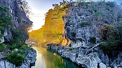
 The Upper Tabuating Dam at Brgy. Nazareth


See also
References
- Municipality of General Tinio | (DILG)
- "2015 Census of Population, Report No. 3 – Population, Land Area, and Population Density" (PDF). Philippine Statistics Authority. Quezon City, Philippines. August 2016. ISSN 0117-1453. Archived (PDF) from the original on May 25, 2021. Retrieved July 16, 2021.
- Census of Population (2020). "Region III (Central Luzon)". Total Population by Province, City, Municipality and Barangay. Philippine Statistics Authority. Retrieved 8 July 2021.
- "PSA Releases the 2021 City and Municipal Level Poverty Estimates". Philippine Statistics Authority. 2 April 2024. Retrieved 28 April 2024.
- Philippine Statistics Authority. 2024 Census of Population.
- Philippine Statistics Authority. 2024 Census of Population.
- Republic Act No. 1665 (1957).
- Department of Environment and Natural Resources (DENR). Protected Area Management information.
- Buzeta, Manuel; Bravo, Felipe (1851). Diccionario Geográfico-Estadístico-Histórico de las Islas Filipinas (in Spanish). Vol. 2. Madrid: José C. de la Peña. p. 392.
- "Expediente instruido sobre la separación en lo civil de San Ysidro y San Antonio Abad de su matriz Gapan". National Archives of the Philippines. 1842-09-03. Retrieved 9 June 2026.
- Foreman, John (1906). The Philippine Islands (3rd ed.). New York: Charles Scribner's Sons. pp. 467–468.
- "Relación de las piezas del expediente que se remite al Arzobispo sobre la separación en lo civil y espiritual de los pueblos de San Isidro y San Antonio de su matriz Gapan, provincia de la Pampanga". National Archives of the Philippines. 1848-10-21. Retrieved 9 June 2026.
- Buzeta, Manuel; Bravo, Felipe (1851). Diccionario Geográfico-Estadístico-Histórico de las Islas Filipinas (in Spanish). Vol. 2. Madrid: José C. de la Peña. p. 392.
- "Papaya Historical Data Papers" (PDF). National Library of the Philippines Historical Data Papers Collection. Retrieved 28 June 2026.
- "Felipe Padilla de Leon". National Commission for Culture and the Arts. Retrieved 9 June 2026.
- "Papaya, Nueva Ecija Historical Data Papers" (PDF). National Library of the Philippines Historical Data Papers Collection. Retrieved 9 June 2026.
- The History and Cultural Life of Papaya, Nueva Ecija. Bureau of Public Schools, Division of Nueva Ecija. c. 1950s. p. 1, 3 – via NHCP Memory Project.
- ...
- Dizon, Eusebio Z.; Pawlik, Alfred F. (2010-09-01). "The lower Palaeolithic record in the Philippines". Quaternary International. Oldest Human Expansions in Eurasia: Favouring and Limiting Factors. 223–224: 444–450. Bibcode:2010QuInt.223..444D. doi:10.1016/j.quaint.2009.10.002. ISSN 1040-6182.
- "ABOUT - General Tinio, Nueva Ecija | The Official Website". www.generaltinio.gov.ph. Archived from the original on 2026-03-05. Retrieved 2026-04-11.
- "Protected Area Information System (PAIS): DENRRE30009". Protected Area Information System (PAIS). Biodiversity Management Bureau, Department of Environment and Natural Resources. Retrieved April 11, 2026.
- "General Tinio Tourism Profile". General Tinio Official Website. Retrieved April 12, 2026.
- Baguinon, Nestor T; Lasco, Rodel D; Macandog, Damasa M; Pasicolan, Paulo N; Villancio, Virgilio T (January 2007). Agroforestry and Land Use in the Philippines. Republic of the Philippines: World Agroforestry Centre. ISBN 978-971-93153-4-6.
{{cite book}}: CS1 maint: date and year (link) - Rodriguez, R.S. (2015). "The Effects of Agroforestry Practices on Soil Properties" (PDF). NVSU Research Journal. Retrieved 2026-04-11.
- Lalican, E.R. (2018). "An Assessment of Agroforestry Systems in Selected Community-Based Forest Management Areas in Laguna, Philippines". Philippine Journal of Agricultural Economics. 2 (1): 25–46. doi:10.7719/pjae.v2i1.545. Retrieved 2026-04-11.
- "Republic Act No. 5100". lawphil.net. Retrieved 2026-04-12.
- Pecundo, Mh (2021). "First report of myxomycetes in the karst forest of Minalungao National Park, Nueva Ecija, Philippines with updates on the limestone-inhabiting myxomycetes of the Philippines" (PDF). Current Research in Environmental & Applied Mycology. 11 (1): 230–247. doi:10.5943/cream/11/1/17.
- Pawlik, Alfred (2008-01-24). "[ARCHAEOLOGY IN ISLAND SOUTHEAST ASIA AND OCEANIA] The Palaeolithic site of Arubo 1 in central Luzon, Philippines". Bulletin of the Indo-Pacific Prehistory Association. 24. doi:10.7152/bippa.v24i0.11866 (inactive 9 May 2026). ISSN 1835-1794.
{{cite journal}}: CS1 maint: DOI inactive as of May 2026 (link) - "BARANGAYS - General Tinio, Nueva Ecija | The Official Website". www.generaltinio.gov.ph. Archived from the original on 2026-03-05. Retrieved 2026-04-11.
- Mines and Geosciences Bureau (2010). Geology of the Philippines (PDF) (2nd ed.). Quezon City: Mines and Geosciences Bureau, Department of Environment and Natural Resources.
- Asio, Victor B.; Oraiz, Kenneth; Saz, Vincent O.; Cascante, Maria Daisy; Galvez, Shaira Mae (2021). "Characteristics and Nutrient Status of Limestone Soils in Leyte and Samar, Philippines". In V.N. Mishra; P.K. Rai; P. Singh (eds.). Geo-Information Technology in Earth Resources Monitoring and Management. New York: Nova Science Publishers. pp. 211–227. Retrieved 12 April 2026.
- Dizon, Eusebio Z.; Pawlik, Alfred F. (2010-09-01). "The lower Palaeolithic record in the Philippines". Quaternary International. 223–224: 444–450. Bibcode:2010QuInt.223..444D. doi:10.1016/j.quaint.2009.10.002. ISSN 1040-6182.
- "Soil pH Map of Nueva Ecija" (PDF). Department of Agriculture. Bureau of Soils and Water Management (BSWM). Retrieved 12 April 2026.
- Pawlik, Alfred F. (2001). "Is there an Early Palaeolithic in the Philippines? New approaches for lithic analysis at the Archaeological Studies Program of the University of the Philippines". Australasian Archaeometry Conference.
- Garong, Ame M. (2001). Preliminary Report of the Archaeological Undertakings in Nicanor Aves Sr. Property Site, General Tinio, Nueva Ecija (Report). National Museum of the Philippines.
- Mijares, Armand Salvador B. (2001). "An Expedient Lithic Technology in Northern Luzon (Philippines)". Lithic Technology. 26 (2): 138–152. doi:10.1080/01977261.2001.11720983.
- Pawlik, Alfred F. (2002). "Acheulean in Nueva Ecija? A Report from the 2001 ASP Fieldschool in Arubo, General Tinio, Nueva Ecija, Central Luzon". Hukay: Bulletin of the University of the Philippines Archaeological Studies Program. 4 (1): 1–22.
- Lepre, Christopher J. (2011). "An earlier origin for the Acheulian". Nature. 477 (7362): 82–85. Bibcode:2011Natur.477...82L. doi:10.1038/nature10372. PMID 21886161.
- Movius, H. L. (1944). "Early Man and Pleistocene Stratigraphy in Southern and Eastern Asia". Papers of the Peabody Museum of American Archaeology and Ethnology. 19.
- Hou, Yamei (2000). "Mid-Pleistocene Acheulean-like stone technology of the Bose Basin, South China". Science. 287 (5458): 1622–1626. Bibcode:2000Sci...287.1622Y. doi:10.1126/science.287.5458.1622. PMID 10698732.
- Bellwood, Peter (1985). Prehistory of the Indo-Malaysian Archipelago. Academic Press.
- Bellwood, Peter (1985). Prehistory of the Indo-Malaysian Archipelago. Academic Press.
- "PAGASA". bagong.pagasa.dost.gov.ph. Retrieved 2026-04-12.
- "General Tinio: Average Temperatures and Rainfall". Meteoblue. Retrieved 4 May 2020.
- Census of Population (2015). "Region III (Central Luzon)". Total Population by Province, City, Municipality and Barangay. Philippine Statistics Authority. Retrieved 20 June 2016.
- Census of Population and Housing (2010). "Region III (Central Luzon)" (PDF). Total Population by Province, City, Municipality and Barangay. National Statistics Office. Retrieved 29 June 2016.
- Censuses of Population (1903–2007). "Region III (Central Luzon)". Table 1. Population Enumerated in Various Censuses by Province/Highly Urbanized City: 1903 to 2007. National Statistics Office.
- "Province of". Municipality Population Data. Local Water Utilities Administration Research Division. Retrieved 17 December 2016.
- "Poverty incidence (PI):". Philippine Statistics Authority. Retrieved December 28, 2020.
- "Estimation of Local Poverty in the Philippines" (PDF). Philippine Statistics Authority. 29 November 2005.
- "2003 City and Municipal Level Poverty Estimates" (PDF). Philippine Statistics Authority. 23 March 2009.
- "City and Municipal Level Poverty Estimates; 2006 and 2009" (PDF). Philippine Statistics Authority. 3 August 2012.
- "2012 Municipal and City Level Poverty Estimates" (PDF). Philippine Statistics Authority. 31 May 2016.
- "Municipal and City Level Small Area Poverty Estimates; 2009, 2012 and 2015". Philippine Statistics Authority. 10 July 2019.
- "PSA Releases the 2018 Municipal and City Level Poverty Estimates". Philippine Statistics Authority. 15 December 2021. Retrieved 22 January 2022.
- "PSA Releases the 2021 City and Municipal Level Poverty Estimates". Philippine Statistics Authority. 2 April 2024. Retrieved 28 April 2024.
- NHCP, History and Cultural Life of Papaya.
- Buzeta & Bravo, Diccionario Geográfico... (1850).
- ...
- Buzeta & Bravo (1850).
- Spanish administrative records.
- NHCP manuscript.
- Historical studies on Spanish colonial local government.
- Philippine Commission reports.
- NHCP manuscript.
- NHCP manuscript.
- "History of General Tinio". Municipality of General Tinio. Retrieved 28 June 2026.
- "History of General Tinio". Municipality of General Tinio. Retrieved 28 June 2026.
- Agoncillo, Teodoro A. (1990). History of the Filipino People. Garotech Publishing.
- "History of General Tinio". Municipality of General Tinio. Retrieved 28 June 2026.
- The Revised Administrative Code of 1917. Manila: Bureau of Printing. 1917.
- "Republic Act No. 1665". The Lawphil Project. Retrieved 28 June 2026.
- "History of General Tinio". Municipality of General Tinio. Retrieved 28 June 2026.
- "Presidential Decree No. 86, s. 1972". Supreme Court E-Library. Retrieved 28 June 2026.
- Presidential decrees on barangay government.
- "Republic Act No. 7160 – Local Government Code of 1991". Official Gazette of the Republic of the Philippines. Retrieved 28 June 2026.
- "Republic Act No. 10742 – Sangguniang Kabataan Reform Act of 2015". Official Gazette of the Republic of the Philippines. Retrieved 28 June 2026.
- "The 1987 Constitution of the Republic of the Philippines". Official Gazette of the Republic of the Philippines. Retrieved 28 June 2026.
- "Republic Act No. 7160 – Local Government Code of 1991". Official Gazette of the Republic of the Philippines. Retrieved 28 June 2026.
- "Republic Act No. 7160 – Local Government Code of 1991". Official Gazette of the Republic of the Philippines. Retrieved 28 June 2026.
- "Republic Act No. 10742 – Sangguniang Kabataan Reform Act of 2015". Official Gazette of the Republic of the Philippines. Retrieved 28 June 2026.
- "Republic Act No. 8371 – Indigenous Peoples' Rights Act of 1997". Official Gazette of the Republic of the Philippines. Retrieved 28 June 2026.
- "History of General Tinio". Municipality of General Tinio. Retrieved 28 June 2026.
- "Republic Act No. 8371 – Indigenous Peoples' Rights Act of 1997". Official Gazette of the Republic of the Philippines. Retrieved 28 June 2026.
- "History of General Tinio". Municipality of General Tinio. Retrieved 28 June 2026.
- "Republic Act No. 4475". The Lawphil Project. Retrieved 28 June 2026.
- "History of General Tinio". Municipality of General Tinio. Retrieved 28 June 2026.
- "Republic Act No. 8371 – Indigenous Peoples' Rights Act of 1997". Official Gazette of the Republic of the Philippines. Retrieved 28 June 2026.
- "Republic Act No. 7160 – Local Government Code of 1991". Official Gazette of the Republic of the Philippines. Retrieved 28 June 2026.
- "History and Cultural Life of Papaya (Historical Data Papers)". National Historical Commission of the Philippines. Retrieved 28 June 2026.
- "Elected Officials of General Tinio 2013–2016". Generaltinio.gov.ph. 2010-07-12. Retrieved 2016-11-23.
- Historical Data Papers: Peñaranda, Nueva Ecija. Bureau of Public Schools. 1953.
- "Presidential Decree No. 557". Lawphil Project.
- "Presidential Decree No. 86". Lawphil Project.
- The History and Cultural Life of Papaya, Nueva Ecija. Bureau of Public Schools. c. 1950s. pp. 9–10 – via NHCP Memory Project.
- ...
- General Tinio official website
- The History and Cultural Life of Papaya, Nueva Ecija. Bureau of Public Schools, Division of Nueva Ecija. c. 1950s. pp. 1–4 – via NHCP Memory Project.
- Municipality of General Tinio official website
- ...
- The History and Cultural Life of Papaya, Nueva Ecija. Bureau of Public Schools, Division of Nueva Ecija. c. 1950s – via NHCP Memory Project.
- The History and Cultural Life of Papaya, Nueva Ecija. Bureau of Public Schools, Division of Nueva Ecija. c. 1950s. pp. 12–14 – via NHCP Memory Project.
- ...
- General Tinio official website / parish source
- The History and Cultural Life of Papaya, Nueva Ecija. Bureau of Public Schools, Division of Nueva Ecija. c. 1950s. pp. 11–12 – via NHCP Memory Project.
- ...
- Municipality of General Tinio official website
- The History and Cultural Life of Papaya, Nueva Ecija. Bureau of Public Schools, Division of Nueva Ecija. c. 1950s – via NHCP Memory Project.
- The History and Cultural Life of Papaya, Nueva Ecija. Bureau of Public Schools, Division of Nueva Ecija. c. 1950s – via NHCP Memory Project.
- ...
- ...
- Local marker, Barangay San Pedro
- Barangay San Pedro marker inscription
- Historical Data Papers: Papaya, Nueva Ecija. Bureau of Public Schools. 1950s.
- Historical Data Papers: Papaya, Nueva Ecija. Bureau of Public Schools. 1950s.
- "About General Tinio". Municipality of General Tinio. Retrieved 2026-05-03.
- "About General Tinio". Municipality of General Tinio. Retrieved 2026-05-03.
- "Penyaranda". Philippine Historic Sites and Structures Registry. National Historical Commission of the Philippines. Retrieved 18 May 2026.
- "History and Cultural Life of Papaya, Nueva Ecija". National Memory Project. National Historical Commission of the Philippines. Retrieved 18 May 2026.
- "Mariano Llanera (1855–1942)". Philippine Historic Sites and Structures Registry. National Historical Commission of the Philippines. Retrieved 18 May 2026.
- Alfonso, Ian Christopher B. (2022). "The Philippine Revolution in Macabebe, Pampanga, and Its Aftermath". Philippine Studies: Historical and Ethnographic Viewpoints. 70 (3): 335–376. doi:10.13185/2244-1638.1133. JSTOR 48815279.
- Santiago, Fernando A. Jr. (2–4 March 2015). A Historical Evaluation of the Emergence of Nueva Ecija as the Rice Granary of the Philippines. DLSU Research Congress 2015. Manila: De La Salle University.
- Kerkvliet, Benedict J. (1971). "Peasant Society and Unrest Prior to the Huk Revolution in the Philippines" (PDF). Asian Studies. 9 (2): 164–192. Retrieved 18 May 2026.
- Kerkvliet, Benedict J. (1971). "Peasant Society and Unrest Prior to the Huk Revolution in the Philippines" (PDF). Asian Studies. 9 (2): 164–192. Retrieved 18 May 2026.
- The Hukbalahap Insurrection (PDF). Center of Military History, United States Army. Retrieved 18 May 2026.
- "General Information". Municipality of General Tinio. Municipal Government of General Tinio. Retrieved 18 May 2026.
- "The Battle of Luzon: Demonstrating U.S. Army Landpower in the Indo-Pacific". U.S. Army. United States Army. 3 April 2025. Retrieved 18 May 2026.
- "Presidential Decree No. 86, s. 1972". The Lawphil Project. Retrieved 18 May 2026.
- "Presidential Decree No. 557, s. 1974". The Lawphil Project. Retrieved 18 May 2026.
- "Masterlist of Schools" (PDF). Department of Education. January 15, 2021. Retrieved August 16, 2025.
- "About General Tinio". General Tinio, Nueva Ecija Official Website. Municipality of General Tinio. Retrieved May 18, 2026.
- "General Tinio, Nueva Ecija Official Website". General Tinio, Nueva Ecija Official Website. Municipality of General Tinio. Retrieved May 18, 2026.
- Buzeta, Manuel; Bravo, Felipe (1851). Diccionario geográfico, estadístico, histórico de las Islas Filipinas. Vol. 2. Madrid: Imprenta de D. José C. de la Peña. Retrieved May 18, 2026.
- Resolution No. 32-S-2026, recognizing Hacienda Severa and other local heritage properties and cultural resources of General Tinio, Nueva Ecija (Sangguniang Bayan resolution). General Tinio, Nueva Ecija: Sangguniang Bayan of General Tinio, Nueva Ecija. May 11, 2026.
- "General Tinio, Nueva Ecija Official Website". General Tinio, Nueva Ecija Official Website. Municipality of General Tinio. Retrieved May 18, 2026.
- "Talapamana ng Pilipinas Cultural Property Database". Talapamana ng Pilipinas. National Commission for Culture and the Arts. Retrieved May 18, 2026.
- "General Tinio, Nueva Ecija Official Website". General Tinio, Nueva Ecija Official Website. Municipality of General Tinio. Retrieved May 18, 2026.
- "General Tinio, Nueva Ecija Official Website". General Tinio, Nueva Ecija Official Website. Municipality of General Tinio. Retrieved May 18, 2026.
- The History and Cultural Life of Papaya, Nueva Ecija (Historical data paper preserved through the National Historical Commission of the Philippines Memory Project). Bureau of Public Schools, Division of Nueva Ecija. pp. 32–33.
- "Talapamana ng Pilipinas Cultural Property Database". Talapamana ng Pilipinas. National Commission for Culture and the Arts. Retrieved May 18, 2026.
- Ibarra, Florante P. (2017). "Transmission of Araquio Music, Songs, and Movement Conventions: Learning, Experience, and Meaning in Devotional Theatre". The Qualitative Report. 22 (4): 1031–1049. doi:10.46743/2160-3715/2017.2699.
- Delos Santos, Michael C.; Demeterio, Feorillo A. III (2020). "Telescopings and Moro-fications in the Four Arakyo Manuscripts of Peñaranda, Nueva Ecija: A Historical/Hagiographical Recontextualization towards a More Culturally-Sensitive Komedya". Humanities Diliman. 17 (1): 74–97.
- Ibarra, Florante P. (2006). "The Araquio of Sto. Tomas, Peñaranda, Province of Nueva Ecija: A Study on the Music in Devotional Theater". Socioeconomic Research Portal for the Philippines. Philippine Institute for Development Studies. Retrieved May 18, 2026.
- Ibarra, Florante P. (2017). "Transmission of Araquio Music, Songs, and Movement Conventions: Learning, Experience, and Meaning in Devotional Theatre". The Qualitative Report. 22 (4): 1031–1049. doi:10.46743/2160-3715/2017.2699.
- "General Tinio, Nueva Ecija Official Website". General Tinio, Nueva Ecija Official Website. Municipality of General Tinio. Retrieved May 18, 2026.
- "About General Tinio". General Tinio, Nueva Ecija Official Website. Municipality of General Tinio. Retrieved May 18, 2026.
- Buzeta, Manuel; Bravo, Felipe (1851). Diccionario geográfico, estadístico, histórico de las Islas Filipinas. Vol. 2. Madrid: Imprenta de D. José C. de la Peña. Retrieved May 18, 2026.
- "About General Tinio". General Tinio, Nueva Ecija Official Website. Municipality of General Tinio. Retrieved May 18, 2026.
- "Felipe Padilla de Leon". CulturEd: Philippine Cultural Education Online. National Commission for Culture and the Arts. Retrieved May 18, 2026.
- "Felipe Padilla de Leon". CulturEd: Philippine Cultural Education Online. National Commission for Culture and the Arts. Retrieved May 18, 2026.
- "About General Tinio". General Tinio, Nueva Ecija Official Website. Municipality of General Tinio. Retrieved May 18, 2026.
- "Tourism Profile". General Tinio, Nueva Ecija Official Website. Municipality of General Tinio. Retrieved May 18, 2026.
- "Tourism Profile". General Tinio, Nueva Ecija Official Website. Municipality of General Tinio. Retrieved May 18, 2026.
- "Republic Act No. 5100". The Lawphil Project. Arellano Law Foundation. Retrieved May 18, 2026.
- "Minalungao National Park: Hidden Paradise of Nueva Ecija". General Tinio, Nueva Ecija Official Website. Municipality of General Tinio. June 27, 2025. Retrieved May 18, 2026.
- "About General Tinio". General Tinio, Nueva Ecija Official Website. Municipality of General Tinio. Retrieved May 18, 2026.
- "Hacienda Severa". Facebook. Retrieved 2026-05-28.
- Resolution No. 32-S-2026, recognizing Hacienda Severa and other local heritage properties and cultural resources of General Tinio, Nueva Ecija (Sangguniang Bayan resolution). General Tinio, Nueva Ecija: Sangguniang Bayan of General Tinio, Nueva Ecija. May 11, 2026.
- Resolution No. 32-S-2026, recognizing Hacienda Severa and other local heritage properties and cultural resources of General Tinio, Nueva Ecija (Sangguniang Bayan resolution). General Tinio, Nueva Ecija: Sangguniang Bayan of General Tinio, Nueva Ecija. May 11, 2026.
- Resolution No. 32-S-2026, recognizing Hacienda Severa and other local heritage properties and cultural resources of General Tinio, Nueva Ecija (Sangguniang Bayan resolution). General Tinio, Nueva Ecija: Sangguniang Bayan of General Tinio, Nueva Ecija. May 11, 2026.
- The History and Cultural Life of Papaya, Nueva Ecija (Historical data paper preserved through the National Historical Commission of the Philippines Memory Project). Bureau of Public Schools, Division of Nueva Ecija.
- The History and Cultural Life of Papaya, Nueva Ecija (Historical data paper preserved through the National Historical Commission of the Philippines Memory Project). Bureau of Public Schools, Division of Nueva Ecija.
- "Talapamana ng Pilipinas Cultural Property Database". Talapamana ng Pilipinas. National Commission for Culture and the Arts. Retrieved May 18, 2026.
- Resolution No. 32-S-2026, recognizing Hacienda Severa and other local heritage properties and cultural resources of General Tinio, Nueva Ecija (Sangguniang Bayan resolution). General Tinio, Nueva Ecija: Sangguniang Bayan of General Tinio, Nueva Ecija. May 11, 2026.
- Samson, Helen F. (1976). Contemporary Filipino Composers: Biographical Interviews. Quezon City: Manlapaz Publishing Company.
- "Proclamation No. 1115, s. 1997: Declaring Felipe de Leon as National Artist for 1997". Official Gazette / Lawphil Project. Republic of the Philippines. October 9, 1997. Retrieved 2026-04-24.
- Legarda, Loren (May 12, 2016). "Senate Resolution No. 771: Honoring the Late National Artist for Music Felipe Padilla de Leon" (PDF). Senate of the Philippines. Retrieved May 4, 2026.
- "PASAMBAP Biography". PASAMBAP (Pambansang Samahan ng mga Banda sa Pilipinas). Retrieved 2026-04-24.