Jõelähtme Parish
Jõelähtme vald | |
|---|---|
 | |
 Flag  Coat of arms | |
 Jõelähtme Parish within Harju County | |
| Country | |
| County | |
| Administrative centre | Jõelähtme |
| Government | |
| • Mayor | Andrus Umboja |
| Area | |
• Total | 210.86 km2 (81.41 sq mi) |
| Population (2026) | |
• Total | 8,007[1] |
| • Density | 37.97/km2 (98.35/sq mi) |
| ISO 3166 code | EE-245 |
| Website | www.joelahtme.ee |
Jõelähtme Parish (Estonian: Jõelähtme vald) is a municipality in Estonia. It was established in 1992 and is administratively part of the Harju County, in northwestern Estonia. The parish has a population of 8,007 and an area of 210.86 km2 (81.41 sq mi), the population density is 37.973/km2 (98.350/sq mi)[2]
The administrative centre of Jõelähtme Parish is the village of Jõelähtme. It is located 20 km east from the centre of Estonia's capital, Tallinn.
Local government
The current mayor (vallavanem) is Andrus Umboja[3] and chairman of the council (volikogu esimees) is Art Kuum.[4]
Demographics
As of 1 January 2026, the parish had 8,007 residents, of which 4,034 (50.4%) were women and 3,973 (49.6%) were men.[5]
Religion
The religious landscape of Jõelähtme rural municipality is predominantly secular, with 76.6% of the population identifying as religiously unaffiliated. Among those older than fifteen years residents who do associate themselves with a faith, 11.4% identify as Orthodox and 8.3% as Lutheran, while other Christian denominations make up 0.9% of the population. 2.8% of the population follows other religions or did not specify their religious affiliation.[6]
Geography
Settlements
There are two small boroughs (est: alevikud, sg. alevik) – Kostivere and Loo – and 34 villages (est: külad, sg. küla) in Jõelähtme Parish.
Landmarks
- Jägala Falls
- Rebala Heritage Reserve
- Kostivere karst area
- Jõelähtme church
- Kaberneeme beach
- Kalevi-Liiva memorial
- Ülgase caves
Gallery
 Saha chapel
 Bronze Age stone cist graves

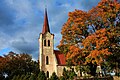 Jõelähtme church
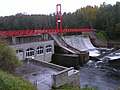 Linnamäe hydroelectric power plant
 Memorial at Kalevi-Liiva
 Monument to the Estonian War of Independence
 Maardu manor house
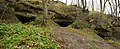 Ülgase caves
 Rammu Island
 Mouth of the Jägala river


_Summer_2014_(1).JPG)


References
- "RV0282U: POPULATION BY SEX, AGE GROUP AND PLACE OF RESIDENCE, 1 JANUARY". PxWeb. Retrieved 2026-05-16.
- "Population figure and composition". Statistics Estonia. Retrieved 9 June 2012.
- "Vallavalitsus" (in Estonian). Jõelähtme Vallavalitsus. Retrieved 11 December 2009.
- "Vallavolikogu koosseis" (in Estonian). Jõelähtme Vallavalitsus. Retrieved 11 December 2009.
- "RV0282U: POPULATION BY SEX, AGE GROUP AND PLACE OF RESIDENCE, 1 JANUARY". PxWeb. Retrieved 2026-05-16.
- "stat.ee".
External links
- Official website (in Estonian)
- Map of Jõelähtme Parish
- Non-official public forum (in Estonian)