Lauchheim | |
|---|---|
 Upper Gate | |
|
Flag  Coat of arms | |
Location of Lauchheim
within Ostalbkreis district 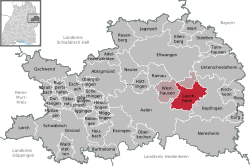 | |
 Location of Lauchheim | |
 Lauchheim  Lauchheim | |
| Coordinates: 48°52′18″N 10°14′40″E / 48.87167°N 10.24444°E / 48.87167; 10.24444 | |
| Country | Germany |
| State | Baden-Württemberg |
| Admin. region | Stuttgart |
| District | Ostalbkreis |
| Government | |
| • Mayor (2023–31) | Andrea Schnele[1] (Ind.) |
| Area | |
• Total | 40.86 km2 (15.78 sq mi) |
| Elevation | 492 m (1,614 ft) |
| Population (2024-12-31)[2] | |
• Total | 4,857 |
| • Density | 118.9/km2 (307.9/sq mi) |
| Time zone | UTC+01:00 (CET) |
| • Summer (DST) | UTC+02:00 (CEST) |
| Postal codes | 73466 |
| Dialling codes | 07363 |
| Vehicle registration | AA, GD |
| Website | www.lauchheim.de |
Lauchheim (German pronunciation: [ˈlaʊxˌhaɪm] ) is a town and municipality with approximately 4800 inhabitants in the Ostalbkreis district, in the Stuttgart region of Baden-Württemberg, Germany.
Geography
Lauchheim is situated on the river Jagst, 12 km northeast of Aalen. It neighbors Westhausen to the north and west, Bopfingen to the east, and Aalen to the south as municipalities. Schloss Kapfenburg, a castle, is located within Lauchheim’s municipality.
Suburbs
Largest suburbs of Lauchheim are Röttingen and Hülen, with smaller ones being Gromberg, Hettelsberg, Stetten, and the depared villages of Tatenloch, Königsbühl, Neusselbuch, Niederhofen, and Mittelhofen.
References
- Bürgermeisterwahl Lauchheim 2023, Staatsanzeiger. Retrieved 13 June 2024.
- "Tabellengruppe 12411: Fortschreibung des Bevölkerungsstandes zum 31. Dezember 2024" [Update of the population as of 31 December 2024] (in German). Statistisches Landesamt Baden-Württemberg.