Svetvinčenat
Sanvincenti | |
|---|---|
Municipality | |
| Svetvinčenat Municipality | |
 | |
 Flag | |
 Location of Svetvinčenat in Istria | |
 Interactive map of Svetvinčenat | |
 Svetvinčenat | |
| Coordinates: 45°05′N 13°53′E / 45.083°N 13.883°E / 45.083; 13.883 | |
| Country | |
| County | |
| Area | |
• Municipality | 30.7 sq mi (79.6 km2) |
| • Urban | 3.0 sq mi (7.7 km2) |
| Elevation | 820 ft (250 m) |
| Population (2021)[2] | |
• Municipality | 2,179 |
| • Density | 70.9/sq mi (27.4/km2) |
| • Urban | 245 |
| • Urban density | 82/sq mi (32/km2) |
| Time zone | UTC+1 (CET) |
| • Summer (DST) | UTC+2 (CEST) |
| Postal code[3] | 52341 Žminj |
| Area code | 52 |
| Website | svetvincenat |
Svetvinčenat (Italian: Sanvincenti, Chakavian: Savičenta, or Savicjenta) is a village and municipality in the south of the central part of Istria, west Croatia, about 25 km southwest of Pazin and 25 km northeast of Pula.
Description
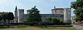
Svetvinčenat was first mentioned ca. 965 C.E., when the town began to grow around a Benedictine abbey. The town is dominated by Grimani Castle which has two round towers and a living quarters. The castle's current form dates from 1589 when the Venetian Marino Grimani renovated and bought it. The castle was burnt down in 1945 and abandoned until the 1990s. It was extensively renovated between 2017 and 2020.[4] Grimani Castle is one of the best-preserved examples of Venetian architecture in Istria. [5]
The town also has a number of churches, the oldest dating form the 13th century.
Demographics
According to the 2021 census, its population was 2,179 with 245 living in the village proper.[2] It was 2,202 in 2011.[6]
The municipality consists of the following settlements:[2]
- Bibići, population 139
- Bokordići, population 76
- Boškari, population 39
- Bričanci, population 69
- Butkovići, population 208
- Cukrići, population 172
- Čabrunići, population 152
- Foli, population 50
- Juršići, population 202
- Kranjčići, population 66
- Pajkovići, population 56
- Peresiji, population 37
- Pusti, population 40
- Raponji, population 61
- Režanci, population 200
- Salambati, population 27
- Smoljanci, population 198
- Svetvinčenat, population 245
- Štokovci, population 142
| population | 2578 | 3174 | 3083 | 3230 | 3681 | 4136 | 4091 | 4517 | 4067 | 3861 | 3556 | 2773 | 2345 | 2204 | 2218 | 2202 | 2179 |
| 1857 | 1869 | 1880 | 1890 | 1900 | 1910 | 1921 | 1931 | 1948 | 1953 | 1961 | 1971 | 1981 | 1991 | 2001 | 2011 | 2021 |
Gallery
 Grimani castle
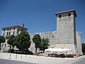 Grimani castle
 Castle entrance
 Inside the castle
 Church of Saint Vincent


References
- Register of spatial units of the State Geodetic Administration of the Republic of Croatia. Wikidata Q119585703.
- "Population by Age and Sex, by Settlements" (xlsx). Census of Population, Households and Dwellings in 2021. Zagreb: Croatian Bureau of Statistics. 2022.
- List of Croatian settlements and delivery post offices. Wikidata Q125763583.
- "Kako se zapostavljena i požarom uništena tvrđava pretvorila u multimedijalni centar". Jutarnji list (in Croatian). 28 June 2020. Retrieved 29 June 2020.
- "ISTRA.HR". www.istra.hr (in Croatian). Retrieved 2023-04-29.
- "Population by Age and Sex, by Settlements, 2011 Census: Svetvinčenat". Census of Population, Households and Dwellings 2011. Zagreb: Croatian Bureau of Statistics. December 2012.
External links
- Svetvinčenat homepage (in Croatian)
- Overall tourist offer of Svetvinčenat